Chiba Prefecture
Chiba Prefecture is home to Narita International Airport, the Tokyo Disney Resort, and the Keiyō Industrial Zone.
[4] The name was adopted by a branch of the Taira clan, which moved to the area in present-day Chiba City in the late Heian period.
The branch of the Taira adopted the name and became the Chiba clan, and held strong influence over the area of the prefecture until the Azuchi–Momoyama period.
Chiba Prefecture was settled in prehistoric times, as evidenced by the Jōmon period remains in every part of the region.
Kofun burial mounds are found across the prefecture, with the largest group being in Futtsu along Tokyo Bay.
[8] In the Asuka period (538–710), under the Taika Reform of 645, the administrative structure of present-day Chiba Prefecture changed significantly.
Shōen feudal estates were established across the three provinces, and the region became an important source of tax revenue, sending agricultural and other products to the capital in Kyoto.
As the Heian period progressed, however, the kokushi provincial governors came to exert military power independent of the central government in Kyoto.
Coastal fortifications were built along Tokyo Bay, as far south as Tateyama, to protect the capital of the Japanese Empire from attack.
In September 1923, the Great Kanto earthquake has cause of widespread destruction in Chiba Prefecture, most notably in the southernmost part of Boso Peninsula, where 1,300 residents were killed, out of 142,000 deaths.
After the United States took control of Saipan, the northern part of the prefecture (most notably the cities of Chiba and Chōshi) was firebombed.
Coronet planned Kujūkuri Beach as one of two initial landing bases, the other being Hiratsuka via Sagami Bay.
On March 11, 2011, the epicenter of 9.0 magnitude earthquake and tsunami and subsequent Fukushima nuclear disaster that devastated much of the northeastern coast of Honshu, which caused some damage and affected areas in Chiba Prefecture.
[15] Chiba City, Funabashi, Narashino, and especially Urayasu were greatly affected by triple disaster (such as soil liquefaction, and evidence of radioactive materials caused by the Fukushima radiation).
[16][17] As a result of triple disaster and with permanent damage to housing stock, the population of Chiba Prefecture fell for the first time since Spanish flu pandemic in 1918 and Great Kanto earthquake in 1923.
Most of Chiba lies on the hilly Boso Peninsula, a rice farming region: the east coast, known as the Kujūkuri Plain,[19] is an especially productive area.
The most populous zone, in the northwest of the prefecture, is part of the Kantō region that extends into the urban agglomeration of Tokyo and Saitama.
The Kuroshio Current flows near Chiba, which keeps it relatively warm in winter and cooler in summer than neighbouring Tokyo.
In the same period the prefectural government embarked on a large-scale land reclamation program to dredge large plots of waterfront property.
The large-scale construction of factories, warehouses, and docks on this reclaimed land around the Tokyo Bay area ultimately formed the Keiyō Industrial Zone.
In recent years, the government has funded more than eighty industrial parks to bring development further inland as well.
[28] Chiba Prefecture leads the nation in the production of several vegetables, including carrots; cabbage; daikon radish; negi, the ubiquitous Japanese cultivar of the Welsh onion; loquat; nashi, the Japanese cultivar of the pear, which has a two hundred-year history of cultivation in the prefecture; tomatoes; and spinach[29][30] It is the nation's second largest producer of corn.
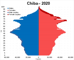
[31] Chiba's population is one of the wealthiest in Japan due to the prefecture's strong commercial and industrial sectors.
Chōshi has been a major center of worldwide soy sauce production since the Edo period, and the prefecture remains the top producer in Japan.
Futomaki in Chiba Prefecture often utilize various ingredients to form a pattern, such as a flower or a kanji character, when the roll is cut and served.
He was reelected overwhelmingly to a second term as governor in the March 2013 election against only a Communist challenger and a minor, unaffiliated independent.
As of 2014, Chiba is divided into 54 contiguous municipalities (see list above): 37 cities, 16 towns and one village,[47] as in all of postwar Japan each with a directly elected mayor and assembly.
As in every prefecture, the police are supervised by the public safety commission; its five members are appointed by the governor with approval by the assembly.


Government Ordinance Designated City Other city Town Village