Saitama Prefecture
The area that would become Saitama Prefecture in the 19th century is part of Musashi Province in the Ritsuryō (or ryō-system; ritsu stands for the penal code, ryō for the administrative code) Imperial administration of antiquity (see Provinces of Japan and the 5 (go) capital area provinces (ki)/7 (shichi) circuits (dō) system) which was nominally revived in the Meiji restoration but has lost much of its administrative function since the Middle Ages.
In the fifth year of the Keiun era (708), deposits of copper were reported to have been found in the Chichibu District of what is now Saitama Prefecture.
At the end of the early modern Edo period, large parts of present-day Saitama were part of the shogunate domain (baku-ryō) or the often subsumed holdings of smaller vassals (hatamoto-ryō) around Edo, major areas were part of the fiefdoms (-han) Kawagoe (ruled by Matsui/Matsudaira, fudai), Oshi (Okudaira-Matsudaira, fudai) and Iwatsuki (Ōoka, fudai); few territories were held by domains seated in other provinces.
In the replacement of -han with -ken, the associated territorial consolidation (removal of feudal era ex-/enclaves) and first wave of prefectural mergers in 1871/72, Oshi and Iwatsuki prefectures were merged into Urawa; after consolidation, it consisted of the entire Saitama District and Northern parts of Adachi and Katsushika (But at that time, "major and minor districts", 大区, daiku and 小区, shōku, served as administrative subdivisions) and was renamed to Saitama.
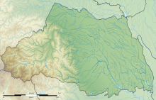
The altitude, highest on the western side, gradually lowers eastward from mountain ranges to hills to plateaus to lowlands.
[9] The eastern side, part of the Kantō Plain, can be further divided into nine separate expanses of hills and ten plateaus.
[10] The western side of the prefecture belongs to the Kantō Mountain Range with Chichibu Basin located in its center.
The area to the west of the basin features high peaks such as Mount Sanpō (2,483 m; 三宝山, Sanpō-yama according to the GSI, but often read Sanpō-zan) on the Western border with Nagano, Saitama's highest mountain,[11] and Mount Kōbushi (2,475 m), in which the Arakawa River has its source.
[14] Rivers and canals, including those developed in the Edo period (17th – 19th centuries) in the east of the prefecture, are largely disused following the introduction of motorised land transport.
Like all prefectural administrations, Saitama's is headed by a governor ([ken-]chiji) who is directly elected to four-year terms since 1947.
The current incumbent is Motohiro Ōno, a former DPFP member of the Diet who was elected in August 2019 with centre-left support (CDP, DPFP, SDP) and 47.9% of the vote against centre-right supported (LDP, Kōmeitō) former baseball player Kenta Aoshima (44.9%) and three other candidates.
The latest prefecture-wide election was the House of Councillors by-election in October 2019 to fill the seat vacated by Motohiro Ōno; it was won by the previous governor Kiyoshi Ueda who has a centre-left background (DPJ member of the House of Representatives for Saitama's 4th district before his term as governor), but without full-scale party backing and without any other major party-backed candidate in the race.
[19] Saitama Prefecture has a number of sister city relationships with states and a province as listed below (in chronological order).
Most of the popular tourist sites in Saitama are located in the northwestern part of the prefecture, which is known as the Chichibu Region.
This region mostly consists of a hilly and moderately mountainous area, and is situated in a rich natural environment.
The region is very popular among residents of Saitama and neighboring prefectures for short trips, as it is easily accessible via the railroad network.

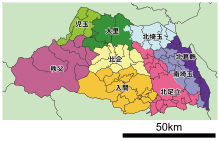
Government Ordinance Designated City City Town Village