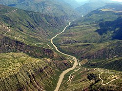
Chicamocha Canyon
With a maximum depth of 2,000 metres (6,600 ft), an area of 108,000 hectares (270,000 acres) and a length of 227 kilometres (141 mi), the canyon is the second-largest worldwide.
The canyon is a major tourist attraction at approximately 55 kilometres (34 mi) from the capital of Santander, Bucaramanga and close to backpacker destination San Gil.
National Route 45A, connecting Bogotá with Bucaramanga, between San Gil and Piedecuesta crosses the canyon and offers spectacular sights on both sides of the Chicamocha River.
The Chicamocha Canyon started forming in the Early Oligocene, when Colombia was undergoing a tectonically active phase of the Andean orogeny.
The Sierra Nevada de Santa Marta was emplaced during the Eocene and active subduction of the Caribbean and Coiba Plates caused uplift in the Eastern Ranges.
[2] The name Chicamocha in the Guane language of the Muisca means "silver thread on a full moon night in the mountain range".
The canyon is the result of the erosion caused by the Chicamocha River, which erosional forces created deep cliffs on both sides.
[7] The canyon represents the southern boundary of the Mesa de Los Santos, a seismically active area known as the Bucaramanga Nest.
[17] Following a hiatus, typical for Colombian geology spanning the Silurian, the Devonian Floresta Formation unconformably overlies the Lower Paleozoic section.