Chimborazo
Chimborazo (Spanish pronunciation: [tʃimboˈɾaso] ⓘ) is a stratovolcano situated in Ecuador in the Cordillera Occidental range of the Andes.
It is a popular destination for mountaineering due to its challenging climbing routes, which involve traversing snow, ice, and rocky terrain.
Local Quichua speakers say that Chimborazo is a Hispanicized pronunciation of "chimbarazu", meaning "the snow on the other side".
Under clear conditions, the summit of Chimborazo can be seen from the coastal city Guayaquil, nearly 140 km (87 mi) away.
Chimborazo is in la Avenida de los Volcanes (the Avenue of Volcanoes) west of the Sanancajas mountain chain.
[citation needed] There are many microclimates near Chimborazo, varying from desert in the Arenal to the humid mountains in the Abraspungo valley.
Chimborazo glacier's ice mass has decreased over the past decades, which is thought to be in large part due to climate change, as well as ash cover from recent volcanic activity[note 2] at Tungurahua, and the El Niño phenomenon.
In earlier days, the people transported ice for cooling uses down to coastal towns such as Babahoyo or Vinces.
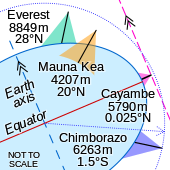
[12] With an elevation of 6,263 m (20,548 ft),[note 1] Chimborazo is the highest mountain in Ecuador and the Andes north of Peru; it is higher than any more northerly summit in the Americas.
Yet, due to its height above the surrounding terrain and local gravity anomalies, the summit of Huascarán is the place on Earth with the smallest gravitational force.
[17] This type of volcano is characterized as having low slopes at the bottom that gradually get steeper the higher up the mountain.
Chimborazo's upper elevations are covered in glaciers that are decreasing in size due to climate change and falling ash from the nearby volcano, Tungurahua.
About 35,000 years ago a collapse of Chimborazo produced a debris avalanche with an average thickness of forty meters, which underlies the city of Riobamba.
In June 1802, during his expedition to South America, the Prussian-born traveler Alexander von Humboldt, accompanied by the French botanist Aimé Bonpland and the Ecuadorian Carlos Montúfar, tried to reach the summit.
[24] In August 1976, SAETA Flight 232 carrying 55 passengers and four crew members aboard a Vickers Viscount from Quito to Cuenca disappeared en route.
In February 2003, after almost 27 years,[25] the aircraft was found with the bodies of its 59 occupants at an elevation of 5,310 meters (17,420 ft) on Chimborazo by Ecuadorian climbers, on the rarely used eastern route Integral.
There are several other less used and more challenging routes on the mountain's other faces and ridges leading to one of Chimborazo's summits: Main (Whymper, Ecuador), Politecnico (Central), N. Martinez (Eastern).
Climbing Chimborazo is dangerous due to the risk of avalanches, the severe weather conditions, and the fact that it is covered in glaciers.
Climbing begins at night in order to reach the summit before sunrise when the snow melts, which increases the chance of avalanche and rockfall.
On November 10, 1993 three parties of climbers, one ascending and two descending, were caught in an avalanche on the steep slopes below the Veintimilla summit.