Mauna Kea
This dry prominence is greater than Everest's height above sea level of 8,848.86 m (29,032 ft), and some authorities have labeled Mauna Kea the tallest mountain in the world, from its underwater base.
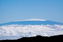
Late volcanism has also given it a much rougher appearance than its neighboring volcanoes due to construction of cinder cones, decentralization of its rift zones, glaciation on its peak, and weathering by the prevailing trade winds.
Ancient Hawaiians living on the slopes of Mauna Kea relied on its extensive forests for food, and quarried the dense volcano-glacial basalts on its flanks for tool production.
When Europeans arrived in the late 18th century, settlers introduced cattle, sheep, and game animals, many of which became feral and began to damage the volcano's ecological balance.
Given how much Mauna Kea protrudes from the Hawaiian Trough, some authorities have called it the tallest (as opposed to highest) mountain in the world, as measured from base to peak.
[28] The Hawaii island volcanoes are the most recent evidence of this process that, over 70 million years, has created the 6,000 km (3,700 mi)-long Hawaiian Ridge–Emperor seamount chain.
[28][31] The shield-stage lavas that built the enormous main mass of the volcano are tholeiitic basalts, like those of Mauna Loa, created through the mixing of primary magma and subducted oceanic crust.
[32] They are covered by the oldest exposed rock strata on Mauna Kea, the post-shield alkali basalts of the Hāmākua Volcanics, which erupted between 250,000 and 70–65,000 years ago.
[28][33] These changes in lava composition accompanied the slow reduction of the supply of magma to the summit, which led to weaker eruptions that then gave way to isolated episodes associated with volcanic dormancy.
Isotopic composition shows the water present to have been derived from rain coming off Mauna Kea at higher than 2,000 m (6,600 ft) above mean sea level.
Donald Thomas, director of the University of Hawaiʻi's Center for the Study of Active Volcanoes believes one reason to continue study of the aquifers is due to use and occupancy of the higher elevation areas, stating: "Nearly all of these activities depend on the availability of potable water that, in most cases, must be trucked to the Saddle from Waimea or Hilo — an inefficient and expensive process that consumes a substantial quantity of our scarce liquid fuels.
Archaeological evidence suggests that these regions were used for hunting, collecting stone material, and possibly for spiritual reasons or for astronomical or navigational observations.
[51] Around AD 1100, natives established adze quarries high up on Mauna Kea to extract the uniquely dense basalt (generated by the quick cooling of lava flows meeting glacial ice during subglacial eruptions) to make tools.
At peak quarry activity after AD 1400, there were separate facilities for rough and fine cutting; shelters with food, water, and wood to sustain the workers; and workshops creating the finished product.
Native Hawaiians were devastated by introduced diseases; port cities including Hilo, Kealakekua, and Kailua grew with the establishment of trade; and the adze quarries on Mauna Kea were abandoned after the introduction of metal tools.
Individuals likely took trips up Mauna Kea's slopes to visit family-maintained shrines near its summit, and traditions related to ascending the mountain exist to this day.
In addition the ecosystems of Hawaiʻi are under threat from human development including the clearing of land for agriculture; an estimated third of the island's endemic species have already been wiped out.
A lack of soil also retards root growth, makes it difficult to absorb nutrients from the ground, and gives the area a very low water retention capacity.
[5] Plant species found at this elevation include Styphelia tameiameiae, Taraxacum officinale, Tetramolopium humile, Agrostis sandwicensis, Anthoxanthum odoratum, Trisetum glomeratum, Poa annua, Sonchus oleraceus, and Coprosma ernodiodes.
At one stage reduced to a population of just 50 plants,[62] Mauna Kea silversword was thought to be restricted to the alpine zone, but in fact has been driven there by pressure from livestock, and can grow at lower elevations as well.
The reserve is a region of sparsely vegetated cinder deposits and lava rock, including areas of aeolian desert and Lake Waiau.
Wolf spiders (Lycosidae) and forest tent caterpillar moths have also been observed in the same Mauna Kea ecosystem; the former survive by hiding under heat-absorbing rocks, and the latter through cold-resistant chemicals in their bodies.
[55] The largest threat to the ecosystem is grazing by feral sheep, cattle (Bos primigenius),[66] and goats (Capra hircus) introduced to the island in the late 18th century.
Most of the houses on the island were built of koa, and those parts of the forest that survived became a source for firewood to power boilers on the sugarcane plantations and to heat homes.
[60] With the collapse of the sugar industry in the 1990s, much of this land lies fallow but portions are used for cattle grazing, small-scale farming and the cultivation of eucalyptus for wood pulp.
A July 2022 state law responds to the protests by shifting control over the master land lease from the University of Hawaii to the new Mauna Kea Stewardship and Oversight Authority (MKSOA).
Mauna Kea's coastline is dominated by the Hamakua Coast, an area of rugged terrain created by frequent slumps and landslides on the volcano's flank.
The height with its risk of altitude sickness, weather concerns, steep road grade, and overall inaccessibility make the volcano dangerous and summit trips difficult.
Until the construction of roads in the mid-20th century, only the hardy visited Mauna Kea's upper slopes; hunters tracked game animals, and hikers traveled up the mountain.
These travelers used stone cabins constructed by the Civilian Conservation Corps in the 1930s as base camps, and it is from these facilities that the modern mid-level Onizuka Center for International Astronomy telescope support complex is derived.