China–Myanmar border
The boundary area is inhabited by non-Han and non-Burmese peoples, and has been traditionally kept as a buffer region between the various Chinese and Burmese empires.
During the Second World War, the Burma Road was constructed across the border as an Allied supply line for the Chinese forces fighting Japan.
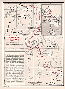
[2] On 28 January 1960, a treaty was signed which delimited most of the border, which was later completed with a full delimitation treaty signed on 1 October 1960, with both sides ceding small areas along the border, such as areas around Kachin Hills/Jiangxinpo[2] and Wa States,[6] which China recognized most of the disputed territory belonging to Burma, while Burma relinquishing small amount of that disputed territory,[7] namely Hpimaw (Pianma) (片馬; 片马; Piànmǎ)[8] and adjacent Gawlam (Gulang) (古浪; Gǔlàng)[9] and Kangfang[2] (崗房; 岗房; Gǎngfáng)[10] to PRC.
[12][13] In recent years several towns along the border, such as Mong La, Ruili and Muse, have become centres of gambling, prostitution and drug smuggling.
Burmese migrants in Chinese border cities live and work within China but endure economic exploitation, spatial confinement and social discrimination.