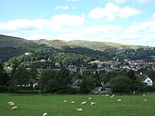
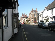
Church Stretton
People have lived in the Stretton Gap (or Dale) for thousands of years; an Iron Age hillfort on Caer Caradoc[4] overlooks the town.
[11] Historically the town was known for its textiles, using the abundant local wool, and a notable location for this industry was Carding Mill Valley (grid reference SO442945).
The cards were wooden blocks with handles and covered in metal spikes, which were angled (to make it easier to untangle) and set in leather.
The carding mill closed and was demolished at the beginning of the twentieth century, though the adjacent factory building remains in the valley today.[when?]
The mill building itself has been converted into flats and a number of other private houses exist near it and the visitor centre, forming a small settlement in the valley.
Church Stretton was nicknamed "Little Switzerland" in late-Victorian and Edwardian times, because of its surroundings and the way many houses hug the hillside.
Today it continues as a hotel and has a number of features and activities in its woodland grounds;[14] it is also a wedding and conference venue.
The charitable service (for blinded armed forces personnel) was moved from Sussex as Church Stretton was thought to be a safe location.
Additionally there is the Mayfair Community Centre on Easthope Road and the St Laurence's Parish Hall on Church Street.
Cunnery is a hillside and collection of houses to the west of the town centre and includes the Long Mynd Hotel.
World's End is where the Ludlow Road curves round the foot of the hillside to the south of the Long Mynd Hotel.
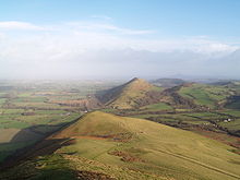
[41] The local geology is complex; the area lies astride the Church Stretton Fault[3] and atop some of the oldest rocks in England – formed over 560 million years ago.
[3] The area also plays a part in the history of geology, Comley Quarry is about 2.5 miles (4 km) from the town and the first site in the British Isles where trilobites were recorded, and gave its name to a regional subdivision of the Cambrian period.
The A49, a primary route and trunk road, runs through the Stretton Gap, connecting Shrewsbury to the north with Ludlow and Hereford to the south.
In 2015, snow gates were installed at various points of access onto the Long Mynd to deter motorists from using the routes in wintry conditions.
[42][43] The gliding club at the southern end of the Long Mynd can be accessed via the Burway from either Asterton or Church Stretton.
Today, there are direct train services to Shrewsbury, Chester, Holyhead, Crewe, Manchester, Ludlow, Hereford, Newport, Cardiff and Swansea.
[48] It is a notable local employer[49] as is the polymer laboratories off Essex Road, currently owned by Agilent Technologies[50] (until 2009 by Varian).
There is a designated light industrial area between the A49 and the railway line, known as Crossways, with a number of businesses, many of which are in the motoring trade, including an independent petrol/diesel filling station.
A recent survey showed that the town has some 50 retail outlets, 44 of which are independently owned, with a diverse range of shop types.
The town also has a number of professional services, such as solicitors, accountants and estate agents, confirming its status as a local centre of business.
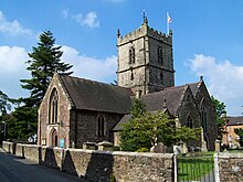
St Laurence's Church has a remnant of its Anglo-Saxon origins: a stone carved fertility symbol called a Sheela na gig.
(usually called simply "Stretton")[64] is a football team who currently play in the West Midlands Regional League Division 2.
[65] Home games are played at Russell's Meadow, located near the centre of the town off Lutwyche Road (grid reference SO455939).
There has been a football field at Russell's Meadow since the 1930s, though the pavilion moved (c. 1950s) from the other side of the Ashbrook to its present location near Lutwyche Road.
Sir John Thynne (c.1515 in Church Stretton – 1580) was the steward to Edward Seymour, 1st Duke of Somerset (c. 1506 – 1552) and a member of parliament.
Amateur footballer Frederick Green (1851–1928), winning side veteran of FA Cup Final of 1874 for Oxford University and of 1877 and 1878 for the Wanderers, died at his last home in the town, The Uplands.
Also, the Olympic bronze-medal archer, Alison Williamson lives in All Stretton and is a member of the town's archery club.
[83] John Jones (born 1930 in Church Stretton-2011) was a British rower who competed at the 1952 Summer Olympics in Helsinki with the men's coxless four where they came fourth.
[88] Stuntman Justin Pearson was born and raised in the town and educated at Church Stretton School, leaving in 1988 to attend Ludlow College.