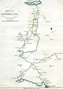
Llangollen Canal
To join the two halves up, a heavily engineered route from Trevor Basin via Ruabon and Brymbo to the River Dee at Chester was planned, but very little of it was built.
There was a growing campaign to reopen it, but it was still designated as one of the 'waterways having insufficient commercial prospects to justify their retention for navigation' under government papers published in 1955 and 1958.
Its importance in the history of the British canal system was recognised in 2009, when the 11-mile (18 km) stretch from Gledrid Bridge near Rhoswiel to Horseshoe Falls including Pontcysyllte and Chirk aqueducts was declared a World Heritage Site by UNESCO.
A capital of £400,000 was authorised, with powers to raise an additional £100,000 if required, and Jessop was appointed as engineer, to be assisted by Duncombe, Thomas Denson and William Turner.
[5] Progress north-westwards from Frankton towards Trevor was hampered by the need to cross two rivers, the Afon Ceiriog at Chirk and the Dee at Pontcysyllte.
Both would require tall aqueducts, but to save construction costs at Pontcysylle, plans were drawn up for three locks at each end, to reduce the height of the main arches by 50 feet (15 m).
Locks would lift the line by 76 feet (23 m) from Trevor basin to Plas Kynaston, after which it would run on the level to Poolmouth and the junction with the Coed Talon Branch.
[12] The network expanded with the opening of the Middlewich Branch on 1 September 1833,[13] and the completion on the Birmingham and Liverpool Junction Canal from Nantwich Basin to Autherley on 2 March 1835.
[18] After the takeover by the London Midland and Scottish Railway, regular maintenance was often not carried out, and gradually the canals silted up, so that boats could not operate with full loads.
The London Midland and Scottish Railway obtained an act of Parliament sanctioning abandonment in 1944, allowing it to close 175 miles (282 km) of canals, including much of the Shropshire Union system.
The flow of hundreds of tons of water washed away the embankment of the railway further down the hill, creating a crater which was 40 yards (37 m) long and 50 feet (15 m) deep.
[21] This caused the first traffic of the morning, a mail and goods train composed of 16 carriages and two vans, to crash into the breach, killing one and injuring two engine crew.
Although there had been little traffic since the end of the First World War, the channel had remained watered, because it supplied the main line of the Shropshire Union Canal.
The state of the canal was poor, and several of the locks were disintegrating, but despite low water levels and thick weed growth, both boats eventually reached Ellesmere.
After several weeks of being stranded, Rolt talked to the Chester office, and they arranged for water to be let down the canal, to enable the boats to return to Hurleston.
[27] In August they were joined by Geoffrey Calvert and his family, who were attempting to reach the top of the canal in a home-made boat, Wagtail, which was pulled by a donkey.
[28] Edward Wilson, another canal enthusiast, reached Trevor in his boat in 1952, and the Inland Waterways Association held a rally at Llangollen later that year.
[29] In 1955, the Board of Survey, a committee chaired by Lord Rusholme, had produced a report on the future of the canals under the control of the British Transport Commission, which they had divided into three categories.
[32] Official attitudes changed, and the provisions of the Transport Act 1968 placed the canals under the control of the British Waterways Board, who were tasked with maintaining, developing and running them for the benefit of users.
[33] The whole of the branch from Hurleston Junction to Llantisilio, just below Horseshoe Falls, was listed in the act of Parliament as a cruising waterway, meaning that its future was no longer in jeopardy.
At that time, potential boaters were advised that the canal was a water supply channel, and that they should submit an application containing full details and dimensions of their boat if they wanted to cruise on it.
It opened in September 2006, and was built in response to a document published by British Waterways in the spring of that year, which outlined development opportunities for farmers and landowners adjacent to the canal.
Both are surrounded by woods, and the canal is fringed by oak trees, many planted by the Shropshire Union Company to ensure that they had supplies of timber to replace their fleet of wooden boats as that became necessary.
A short branch leads into the town,[67] at the end of which is a three-storey, red brick warehouse, dating from the early 19th century, which is grade II listed.
[69] The former stables and stores, which are now used as offices, include an exceptionally early example of a covered dry dock, in which barges were built and repaired.
[73] The towpath is on the eastern bank from the junction to Dobson's Bridge, and then crosses over to the other side, where it remained to the end of the canal at Quina Brook.
The "W" addition was part of a Minimum Safety Standards scheme instigated by British Waterways, to avoid possible confusion, especially for emergency services, of having different bridges on the same canal with the same number.
[83] A number of breaches had occurred on this final section over many years, and in the early 1980s, British Waterways initiated a programme to resolve this issue.
[84] Navigation by powered craft is prohibited beyond the entrance to Llangollen Marina and the final section is used only by horse drawn trip boats.
In 2005, a marina was constructed by British Waterways, just upstream from Llangollen Wharf, to relieve the acute shortage of casual moorings, and provides 33 berths.