Earth's circumference
[2] The first known scientific measurement and calculation was done by Eratosthenes, by comparing altitudes of the mid-day sun at two places a known north–south distance apart.
In modern times, Earth's circumference has been used to define fundamental units of measurement of length: the nautical mile in the seventeenth century and the metre in the eighteenth.
Additionally, the shadow of someone looking down a deep well at that time in Syene blocked the reflection of the Sun on the water.
[13] The method was based on several surveying trips conducted by professional bematists, whose job was to precisely measure the extent of the territory of Egypt for agricultural and taxation-related purposes.
[16] Pliny the Elder mentions Posidonius among his sources and—without naming him—reported his method for estimating the Earth's circumference.
The smaller value offered by Strabo and the different lengths of Greek and Roman stadia have created a persistent confusion around Posidonius's result.
[17] Around AD 525, the Indian mathematician and astronomer Aryabhata wrote Aryabhatiya, in which he calculated the diameter of earth to be of 1,050 yojanas.
[20] Around AD 830, Caliph Al-Ma'mun commissioned a group of Muslim astronomers led by Al-Khwarizmi to measure the distance from Tadmur (Palmyra) to Raqqa, in modern Syria.
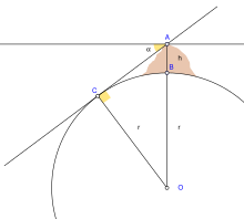
In contrast to his predecessors, who measured the Earth's circumference by sighting the Sun simultaneously from two locations, al-Biruni developed a new method of using trigonometric calculations, based on the angle between a plain and mountain top, which made it possible for it to be measured by a single person from a single location.
If, instead, Columbus had accepted Eratosthenes's larger value, he would have known that the place where he made landfall was not Asia, but rather a New World.
Around that time British mathematician Edmund Gunter improved navigational tools including a new quadrant to determine latitude at sea.
Gunter used Snellius's circumference to define a nautical mile as 6,080 feet, the length of one minute of arc at 48 degrees latitude.
In order to measure this distance accurately, the French Academy of Sciences commissioned Jean Baptiste Joseph Delambre and Pierre Méchain to lead an expedition to attempt to accurately measure the distance between a belfry in Dunkerque and Montjuïc castle in Barcelona to estimate the length of the meridian arc through Dunkerque.