City of Launceston
The municipality logo features the now extinct Tasmanian tiger, an indigenous marsupial that used to be prevalent in the Launceston district.
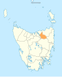
[5] Its original boundaries have long since been redefined and the area now known as the City of Launceston includes parts of the former Lilydale, St Leonard's, Evandale and Westbury Municipalities.
Women were ineligible to stand for election to the Launceston City Council until 1945,[8] despite being granted the same rights at federal and state level in 1902 and 1921, respectively.
• Dilston • East Launceston • Invermay • Kings Meadows • Launceston • Mayfield • Mowbray • Newnham • Newstead • Norwood • Prospect • Punchbowl • Ravenswood • Rocherlea • South Launceston • St Leonards • Summerhill • Trevallyn • Waverley • West Launceston • Youngtown • Bangor • Blessington • Burns Creek • Golconda • Karoola • Lalla • Lebrina • Lilydale • Lower Turners Marsh • Mount Direction • Myrtle Bank • North Lilydale • Nunamara • Patersonia • Pipers Brook • Pipers River • Prospect Vale • Relbia • Retreat • Springfield • Swan Bay • Targa • Tayene • Tunnel • Turners Marsh • Underwood • Upper Blessington • White Hills • Windermere • Wyena Homelessness in Launceston has been a growing problem.
[9][10] Launceston City Council does not hold or track statistics on homelessness but relies on Homes Tasmania to do so.