Guatemala City
The present city was founded by the Spanish after their colonial capital, now called Antigua Guatemala, was destroyed by the devastating 1773 Santa Marta earthquake and its aftershocks.
[5] It became the third royal capital of the surrounding Captaincy General of Guatemala; which itself was part of the larger Viceroyalty of New Spain in imperial Spanish America and remained under colonial rule until the nineteenth century.
Reconstructions since have resulted in a more modern architectural landscape, including wider streets and a grid lay-out for new developments, inspired by post-18th century designs of architects in other national capital cities such as Paris, France and Washington, D.C. Today, Guatemala City is the political, cultural, religious and economic center of the Republic of Guatemala and exerts a wide financial, commercial, and cultural influence on the Central America region and beyond, throughout Latin America.
Human settlement on the present site of Guatemala City began with the native indigenous Maya people, who built a large ceremonial center at Kaminaljuyu.
due to an increase in mining and trading of obsidian, a valuable commodity of volcanic glass (Igneous rock) for the Pre-Columbian American civilizations in Mesoamerica.
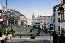
During this period of the late 18th century after the move three years later in 1776 to the current site of modern Guatemala City, that the central plaza in the new town, with its premier landmark neo-classical style architecture of the immense Metropolitan Cathedral (officially named: Catedral Primada Metropolitana de Santiago), built 1782–1815, completed / dedicated 1871.
Also erected in that post-1773 Santa Marta Earthquake was the massive regional colonial Royal Spanish government's Palace of the Captain-General, were constructed in the old second capital of the 1700s, now semi-ruined town Antigua Guatemala and preserved historic site, which later was partially repaired and maintained, even though the capital had been moved away to the current city in Emmita Valley.
The old monumental palace served then as the headquarters for the colonial government regional jurisdiction of the Captaincy General of Guatemala, from its organization in 1542 to independence in 1821.
Although slums that had formed with the major displacement of the city and region's population after the 1917–1918 series of earthquakes, continued to grow and spread around the edges of the capital city with the lack of civilized normal basic amenities and public services / utilities, such as fresh water piping, sewer drainage systems / filtration plants, electric power lines with paved / lighted streets and highways, etc.
In addition to a wide variety of restaurants, hotels, shops, and a modern BRT transport system (Transmetro), the city is home to many art galleries, theaters, sports venues and museums (including some fine collections of Pre-Columbian art) and provides a growing number of cultural offerings.
Guatemala City not only possesses a history and culture unique to the Central American region, it also furnishes all the modern amenities of a world class city, ranging from an IMAX Theater to the Ícaro film festival (Festival Ícaro), where independent films produced in Guatemala and Central America are debuted.
Besides the parks, the city offers a portfolio of entertainment in the region, focused on the so-called Zona Viva and the Calzada Roosevelt, as well as four degrees North.
It is also worth mentioning, that due to the airport being in the south of the city, height limits based on aeronautical considerations have been applied to the construction code.
[10] Despite its location in the tropics, Guatemala City has a monsoon humid subtropical climate (Köppen Cwa)[citation needed] due to its relatively high altitude which moderate the average temperatures.
Lying on the Ring of Fire, the Guatemalan highlands and the Valle de la Ermita are frequently shaken by large earthquakes.
Torrential downpours, similar to the more famous monsoons, occur frequently in the Valle de la Ermita during the rainy season, leading to flash floods that sometimes inundate the city.
Due to these heavy rainfalls, some of the slums perched on the steep edges of the canyons that criss-cross the Valle de la Ermita are washed away and buried under mudslides, as in October 2005.
In February 2007, a very large, deep circular hole with vertical walls opened in northeastern Guatemala City (14°39′2″N 90°29′25″W / 14.65056°N 90.49028°W / 14.65056; -90.49028), killing five people.
[19] This piping feature has since been mitigated by City Hall by providing proper maintenance to the sewerage collection system,[20] and plans to develop the site have been proposed.
However, critics believe municipal authorities have neglected needed maintenance on the city's aging sewerage system, and have speculated that more dangerous piping features are likely to develop unless action is taken.
[22][23][24] The growth of the city's population has been robust, abetted by the mass migration of Guatemalans from the rural hinterlands to the largest and most vibrant regional economy in Guatemala.
As a result, chronic traffic congestion, shortages of safe potable water in some areas of the city, and a sudden and prolonged surge in crime have become perennial problems.
The infrastructure, although continuing to grow and improve in some areas,[26] is lagging in relation to the increasing population of rural migrants, who tend to be poorer.
Due to its small and relatively income-restricted domestic market, Guatemala City produces very little in the way of its own programming outside of local news and sports.
[citation needed] Guatemala City is divided into 22 zones in accordance with the urban layout plan designed by Raúl Aguilar Batres.
Whereas these nine named universities are private, the Universidad de San Carlos remains the only public institution of higher learning.
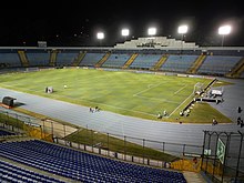
[33] The 2024 Senior Pan American Championships will be held in the city from 7 to 9 June at Gimnasio Nacional Teodoro Palacios Flores.