Tegucigalpa
[42] The most widely accepted version suggests that it comes from the Nahuatl word Taguz-galpa, which means "hills of silver", but this interpretation is uncertain since the natives who occupied the region at the time were unaware of the existence of mineral deposits in the area.
Between the 1930s and 1960s, Tegucigalpa continued to grow reaching a population of over 250,000 people, giving way to what would become one of the biggest neighborhoods in the city, the Colonia Kennedy; the nation's autonomous university, the UNAH; and the construction of the Honduras Maya Hotel.
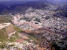
[63][64] Today, Tegucigalpa continues to sprawl far beyond its former colonial core: towards the east, south and west, creating a large but disorganized metropolis.
In an effort to modernize the capital, increase its infrastructure and improve the quality of life of its inhabitants, the administration has passed several ordinances and projects to turn the city around within the upcoming years.
[67] El Picacho Hill, a rugged mountain of moderate height, rises above the downtown area; several neighborhoods, both upscale residential and lower income, are located on its slopes.
Despite being several thousand feet above sea level, the city lacks an efficient flood control system, including canals and sewerage powerful enough to channel rainwater back into the river to flow down to the ocean.
[72] Like much of central Honduras, the city has a tropical climate, though tempered by the altitude—meaning less humid than the lower valleys and the coastal regions—with median temperatures averaging between 19 °C (66 °F) and 23 °C (73 °F) degrees.
The ground was already saturated and could not absorb the heavy precipitation, while deforestation and debris left by the hurricane led to catastrophic flooding throughout widespread regions of the country, especially in Tegucigalpa.
[79] The heavy rain caused flash floods of Choluteca's tributaries, and the swollen river overflowed its banks, tearing down entire neighborhoods and bridges across the ravaged city.
The dam clogged the waters of the river and many of the low-lying areas of Comayagua were submerged; historic buildings located along Calle Real were either completely destroyed or so badly damaged that repair was futile.
[81][82][83] It has seen a rapid growth in the last 30 years,[84] and only recently has the government passed some of the laws establishing city planning and zoning rules.
[85] Surface roads can be narrow with the most important avenues carrying no more than two or three lanes running in each direction, adding to the problem of heavy traffic congestion.
Colonias represent relatively recent 20th-century middle class residential suburbs, some known as residenciales for their upper income development, and these are continuously spreading while the barrios are old inner-city neighborhoods.
It is formed by more than 40 neighborhoods, many of them wealthy middle class residential areas such as Colonia Palmira to the east of the historic center, on Boulevard Morazán, which hosts several foreign embassies as well as upscale restaurants.
[99] Today, there are many religious groups in Tegucigalpa including a Jewish community; Jehovah's Witnesses and the Church of Jesus Christ of Latter-day Saints, who opened a temple in the city in 2013.
[113] The industrial production taking place in the region includes textiles, clothing, sugar, cigarettes, lumber, plywood, paper, ceramics, cement, glass, metalwork, plastics, chemicals, tires, electrical appliances, and farm machinery.
[117] While their contribution to the economy remained small, they boomed at the beginning of the 1990s, mostly concentrating in northern Honduras, but after the mid-1990s they were expanded to the central region, including Tegucigalpa.
The main obstacle to establishing factories in Tegucigalpa has been facilitating infrastructure to provide efficient access between the capital and country's economic hubs: San Pedro Sula and Puerto Cortez.
[120] Foreign real estate and property developers operate in the capital District as well, such as Grupo Roble [es] of the Multiplaza malls.
Tegucigalpa's economic challenges are tied to those of the rest of the country, such as overcoming crime, anomalies in the judicial system, educational backwardness, and deficient infrastructure in order to continue to encourage foreign investors and permit growth of local entrepreneurs.
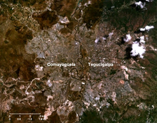
[128] When the Central District was formed on 30 January 1937 under Decree 53 of reformed Article 179 of the 1936 Honduran Constitution, both cities became one political entity sharing the title of Capital of Honduras.
Removal of the mayor or any alderman for any cause is reserved to the Ministry of the Interior, Justice and Decentralization (Secretaría de Gobernación, Justicia y Descentralización).
The National University of Agriculture (UNA), founded in 1950, also state-funded and located in Catacamas, Olancho, maintains a liaison office in Tegucigalpa.
All barrios and colonias in Tegucigalpa can be accessed by automobile, although some neighborhoods in the city suffer from unpaved, narrow, or hilly streets making them difficult to maneuver.
The oldest districts were not built with the advent of the automobile in mind and therefore lack efficient roadways to accommodate the overwhelming number of vehicles.
The Anillo Periférico (beltway or ring road) and Boulevard Fuerzas Armadas (Armed Forces Blvd) are the city's two expressways—equipped with center dividers, interchanges, overpasses and underpasses—allowing for controlled-access traffic.
Despite a network of major highways, none reach directly into the historic downtown, forcing drivers to rely heavily on surface streets.
[162] List of major thoroughfares in the Central District, including urban core arteries and outskirt roads: International highways
In late May 2011, the National Congress approved the project under a new law as part of the financing deal with the Inter-American Development Bank (IAB).
Large commercial jets are required to execute a tight hairpin left turn at very low altitude to land on the short runway.