Geography of Arunachal Pradesh
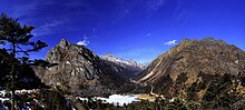
Forest cover: 79.63% (2019)[1] Arunachal Pradesh is primarily a hilly tract nestled in the foothills of the Himalayas in northeast India.
[10][11] Arunachal Pradesh is located in northeast India, bordering Bhutan, Tibet (China) and Myanmar internationally.
[15] The elevation of the towns of Naharlagun, Pasighat and Tezu in the south are 290 m, 155 m and 210 m respectively,[7] while Kangto, Nyegi Kangsang and the Gorichen group of mountains are some of the highest peaks in this region of the Himalayas.
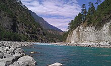
Abrasion by the rivers which flow through the mountains has created a broad valley, which is a major feature of the geography of the state.
Other rivers include Tawang Chu, Dikrong, Ranga, Kamala/Kamla, Kamplang, Siyum, Dihing/ Noadihing and Tirap.
At the lowest elevations, at Arunachal Pradesh's border with Assam, are the Brahmaputra Valley semi-evergreen forests.
[37][44] Orchids, fern, bamboo, cane, rhododendrons, oak, hedychiums, and various medicinal plants form a diverse range of the state's green cover.
Among the crops grow are rice,nigros , maize, millet, wheat, pulses, sugarcane, ginger, and oilseeds.
Its major industries are rice mills, fruit preservation and processing units, and handloom handicrafts Apart from them, the forests of Arunachal are also home to a large number of people belonging to the different tribes.
These tribal people, aloof from urbanization, dwell in these forests where the various forest-based products form a part of their livelihood.
[45] The regions in the lower belts of the state experience hot and humid climates, with a maximum temperature in the foothills reaching up to 40 °C (during the summer).