Climate of Brazil
[1] Temperatures north of the Tropic of Capricorn, especially in low-altitude areas, are high, averaging above 25 °C (77 °F), but not reaching the summer extremes of up to 40 °C (104 °F) in the temperate zones.
[3] However, the summit of Morro da Igreja, a mountain situated in the municipality of Urubici, also in Santa Catarina, recorded a temperature of −17.8 °C (0.0 °F) on 30 June 1996 unofficially.
Although most of Brazil lies in the tropics, more than 60 percent of the country's population live in areas which are cooled either by altitude, sea winds or polar fronts.
Some coastal cities of Rio de Janeiro, Recife and Salvador can get extremely hot, with temperatures exceeding 40 °C (104 °F) in heat waves.
[5] However, plateau cities such as São Paulo, Brasília and Belo Horizonte have mild climates, and the southern cities of Porto Alegre and Curitiba have mild winters, but while Curitiba has a warm summer due to the average elevation of 934.6 metres (3,066 ft), Porto Alegre has a hot summer, with an average elevation of only 10 metres (33 ft).
Rio de Janeiro, Recife, and Salvador on the coast have warm climates, with average temperatures of each month ranging from 23 to 27 °C (73 to 81 °F), but enjoy constant trade winds.
The cities of São Paulo, Curitiba, Florianópolis and Porto Alegre are known to have a subtropical climate, which is within contrast with central and northern Brazil.
It is less widely known that, despite high annual precipitation, the Amazon forest has a three- to five-month dry season, the timing of which varies according to location north or south of the equator.
Snow in Brazil often happens in winter in the mountains of Rio Grande do Sul, Santa Catarina, and Paraná, and is rarer at lower elevations.
[22] Other significant snowfalls where more than 1 metre (39 inches) of snow accumulated happened on 20 July 1957 in São Joaquim[23] and 15 June 1985, in Pico das Agulhas Negras.
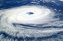
The country's coastal population centers are considered less burdened with the need to prepare for cyclones, as are cities at similar latitudes in the United States and Asia.
In 2011, the Brazilian Navy Hydrographic Center started assigning official names to tropical and subtropical cyclones that develop within its area of responsibility, which is to the west of 20°W, when they have gained sustained wind speeds of 65 kilometres per hour (40 mph) and over.
Large amounts of rain fell in Greater Belo Horizonte, triggering a landslide which killed three people and left one person missing.
At worst, large areas of the Amazon River basin could turn into savannah, with severe consequences for global climate and local livelihoods.
Greenhouse gas emissions by Brazil are over 4% of the annual world total,[54] firstly due to cutting down trees in the Amazon rainforest, which emitted more carbon dioxide in the 2010s than it absorbed,[55] and secondly from large cattle farms, where cows belch methane.