Climate of Argentina
The center of the country, which includes the Pampas to the east and the drier Cuyo region to the west has hot summers with frequent tornadoes and thunderstorms, and cool, dry winters.
Patagonia, in the southern parts of the country has a dry climate with warm summers and cold winters characterized by strong winds throughout the year and one of the strongest precipitation gradients in the world.
The geographic and geomorphic characteristics of Argentina tend to create extreme weather conditions, often leading to natural disasters that negatively impact the country both economically and socially.
The climate of the southern parts of the country is moderated by the surrounding oceans, resulting in cold weather that is less intense and prolonged than at comparable latitudes in the northern hemisphere.
[3] Both the Andes and Sierras Pampeanas affect the climate of Argentina, leading to differences in temperature, pressure, and spatial distribution of precipitation depending on the topography and altitude.
[11]: 7 Owing to the higher altitudes of the Andes north of 40oS, they completely block the normal westerly flow, preventing low pressure systems containing moisture from the Pacific Ocean from coming in.
[25][34] The Chaco Low interacts with the South Atlantic High, generating a pressure gradient that draws moist air from the northeast to coastal and central regions of Argentina.
[25] This is partly responsible for the decrease in winter precipitation over much of Argentina (in addition to northward displacement of westerlies) due to a weaker transport of air masses from the tropics.
[37] Although the exact mechanisms are unknown, the impacts of the changes in atmospheric circulation patterns caused by the El Niño–Southern Oscillation are more clearly observed in the more humid eastern parts of the country (between Uruguay and southern Brazil).
[40]: 13 Cold air anomalies arising from El Niño events are observed during spring and are the result of an increase in rainfall that lead to reductions in insolation.
[24][43] This results in stronger westerly winds in the southern parts of the country while preventing cold fronts from penetrating inland, producing more stable conditions.
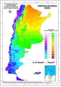
[46] In general, Argentina has four main climate types: warm, moderate, arid, and cold, all determined by the expanse across latitude, range in altitude, and relief features.
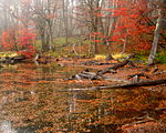
[51][52] Consequently, there is a wide variety of biomes in the country, including subtropical rain forests, semi-arid and arid regions, temperate plains in the Pampas, and cold subantarctic in the south.
[47]: 52 Temperatures in Patagonia exceed 0 °C (32 °F) during winter months and owing to the maritime influences of the surrounding Pacific and Atlantic oceans, the thermal amplitude is smaller than at similar latitudes in the Northern Hemisphere.
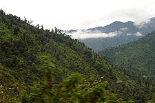
[79] The temperate valleys, the location of major cities such as Salta and Jujuy,[note 2] have an average precipitation ranging between 500 and 1,000 mm (20 and 39 in),[80] with rainfall mainly concentrated in the summer months, often falling in short but heavy bursts.
[81][82] Valleys in the southern parts of the region are drier than those in the north due to the greater height of the Andes and the Sierras Pampeanas on the eastern slopes than the northern mountains, presenting a significant orographic barrier that blocks moist winds from the Atlantic and Pacific oceans.
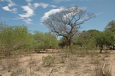
[79] The area further west in the Puna region, with an average altitude of 3,900 m (12,800 ft), is mostly a desert due to the blocking of the easterly winds by the Andes and the northwest extension of the Sierras Pampeanas.
[75][78]: 33 [79][84] Precipitation in the Puna region averages less than 200 mm (8 in) a year while high isolation, strong winds, and low humidity exacerbate the dry conditions.
[14][114] One defining characteristic are the strong winds from the west which blow year round (stronger in summer than in winter), which favors evaporation and is a factor in making the region mostly arid.
[115] The north–south orientation of the Andes creates a barrier for humid air masses coming from the Pacific Ocean, forming an extensive rain shadow and causing most of the region to be arid.
[15][116] South of 52°S, the Andes are lower in elevation, reducing the rain shadow effect in Tierra del Fuego Province and allowing forests to thrive on the Atlantic coast.
[14] The influence of the Pacific Ocean, general circulation patterns, and the topographic barrier caused by the Andes results in one of the strongest precipitation gradients in the world.
[136] These floods can damage infrastructure, cause loss of life, increase the risk of diseases, and negatively impact agricultural productivity, which is one of the main economic activities of the country.
[145][147] In 2018, a severe drought affected the country from the final months of 2017 to April 2018 was the worst in the last 50 years and one of the 10 most destructive climate related events in the world in 2018.
[152] These include areas west of Buenos Aires, which can average more than eight dust storms per year, and parts of Patagonia, owing to its aridity and windy climate.
[158] Severe storms impact large cities more often and can damage cars, houses and disrupt public services such as transportation and collection and disposal of urban solid waste.
[164] The flooding as a result of storm surges are particularly destructive in flat coastal areas such as the Rio de La Plata shores, and the Salado Basin.
[165] The low temperatures brought by these cold waves can cause frosts that can damage plants, severely affecting agricultural production and devastating the local economy.
[64]: 24 [168]: 86–88 In contrast, the Andean part of Patagonia, along with the Cuyo region, has seen a decrease in precipitation, leading to a reduction in river flow in the last 100 years.
[168]: 94 [171] Intense precipitation could become more common, increasing the likelihood of suffering from events such as flooding, since most of its population lives in urban areas near a body of water (rivers, lakes and oceans).