Climate of France
[1] The parameters used to describe a region's climate are many and varied, from temperature, wind and air humidity to soil water content, river conditions, atmospheric composition and ocean salinity.
Abrupt changes of millennial cyclicity punctuated this last glacial period and had a strong impact on terrestrial and marine ecosystems, as well as on atmospheric composition and temperature.
Studies of Bay of Biscay sediments have shown that each Heinrich event is synchronous with the rapid development (< 100 years) of a "Central European-type" grass steppe at the expense of pine forest.
Beyond the Garonne to the east and the Adour to the south, finer particles (loess) carried by storms to higher altitudes were deposited to form accumulations on the relief, where steppe vegetation then developed.
Reindeer and horses (Equus caballus gallicus), sometimes combined with Bovinae (bison or aurochs), became the dominant species of the early Interstadial period, judging by the hunting records of human societies.
Moreover, as Florian Berrouet points out: "The addition of numerous details indicating seasonality or the extreme naturalistic rigor of the artists (anal flap, eye contour, triangular lower lip) and making each animal unique, endowed with a real personality, forces us to believe that man must have rubbed shoulders with, or even observed, these mammoths for a long time."
[11] At the end of the period (Dryas III), a very severe cold snap led to a return of arctic species, a further retreat of forest and an extension of steppe and tundra landscapes.
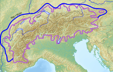
[14] In the mountains of Europe, small glaciers also formed in the Vosges, Black Forest, Massif Central, Carpathians, Pyrenees, Apennines, Balkans and Sierra Nevada, as well as in northwest Spain, Crete and Corsica.
Generally speaking, since agriculture was the Roman Empire's primary source of wealth, it is now clearer that this climatic change was a powerful driving force behind economic development until the 1st.
[20] The settlement and development of the city of Lyon in a flood zone benefited from a favorable climatic context linked to the Little Roman Optimum, corresponding to a period of moderate hydrology.
In Lyon, archaeological digs have shown that the urban society of the city's riverside adapted to this crisis through a series of developments designed to occupy the peninsula between the Rhône and Saône rivers.
It was invented in the 1920s by botanist Wladimir Peter Köppen, who combined the world vegetation map published in 1866 by Hermann Griesbach and the division of climate into five zones by de Candolle.
The Köppen-Geiger map remains a reference today, thanks to its frequent updates, in the fields of hydrology, geography, agriculture, biology and climatology through its research into the evolution of climates.
A large part of mainland France lies in the oceanic domain (Cfb), while the plains and hills bordering the Mediterranean basin have a climate designated by Csa.
Based on station measurements of precipitation and temperature provided by Météo-France, a set of 14 variables incorporating a 30-year time series (1971–2000) was defined to characterize climates and their distinctive modes of variation.
In winter, these winds are very cold and come into contact with milder oceanic air masses, creating or activating vigorous disturbances that generate intense snowfalls and sharp temperature drops.
In addition to the upsurge in rainfall in late summer/autumn, these islands are exposed to devastating tropical cyclones at this time of year, both in terms of the amount of rain dumped in a few hours and the stormy winds associated with them.
Due to the oceanic environment and low latitude, annual averages are high (Ile des Pins 22.5 °C, Saint Denis 24 °C, Le Lamentin 26.2 °C) and temperature differences are not very marked in these regions.
A narrow sector of the enormous Antarctic ice mass, Adélie Land has an extreme polar climate, within the coldest continent on earth, with a very low average winter temperature (−16.5 °C in July at Dumont d'Urville, which is relatively cooler because it's by the sea, but can approach −70 °C in the heart of the continent) and a consistently negative average summer temperature, even along the coast (−0.8 °C in January at Dumont d'Urville, but around −20/−30 °C inland).
In winter, intense cooling is caused by permanent night-time conditions over a continental mass centered on the pole and relatively isolated from thaw by the vigorous westerly flow that prevails in the southern hemisphere's mid-latitudes.
This is the domain of the very violent katabatic wind that blows from the interior of the continent towards the coast, caused by the descent of the icy air that forms on the summit of the Antarctic Plateau (over 3,000 m) towards sea level.
The Aurelhy (Analyse Utilisant le RELief pour l'HYdrométéorologie) model, developed by Météo-France, provides 30-year normals (1951–1980; 1961–1990; 1971–2000; 1981–2010; 1991–2020) and annual statistics for temperature and precipitation parameters.
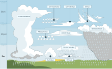
Its aim is to study atmospheric phenomena such as clouds, precipitation and wind, to understand how they form and evolve as a function of measured parameters such as pressure, temperature and humidity.
For example, la bise is a common regional name for the cold, fairly dry north-to-northeasterly wind in central and eastern France and Switzerland, blowing mainly at high altitude.
[112][114] In meteorology, a cloud is a visible mass initially made up of a large number of water droplets (sometimes ice crystals combined with chemical aerosols or minerals) suspended in the atmosphere above the surface of a planet.
[115][116] Météo-France distinguishes three main types of precipitation: Episodes of great geographical extent, affecting one or more departments, with heavy rainfall, usually of long duration (up to several days), but with no remarkable intensity; episodes of great geographical extent, affecting one or more departments, with very high intensities; and localized thunderstorms, which can, over a short period of time and within a limited perimeter, dump huge quantities of water.
[119] According to meteorologist Guillaume Séchet, "as a result of global warming, it is estimated that by 2100 France will experience around 20% more Mediterranean episodes ", with more dramatic consequences due to increasing soil sealing and demographic pressure in the regions concerned.
The summer of 1976 is remembered for the drought that caused the worst agricultural damage, but it was above all a major heatwave in which some twenty départements saw their mortality rates rise by more than 10% above seasonal norms, representing 6,000 excess deaths that went unnoticed at the time.
Climate projections produced by Météo-France in 2021 predict a temperature rise of 2.2 degrees in France by 2100, based on the RCP 4–5 intermediate scenario of the IPCC's Sixth Assessment Report.
However, according to a study published in October 2022 by several scientific institutions, including the Centre national de la recherche scientifique (CNRS) and Météo-France, the temperature rise in France could reach 3.8 degrees in 2100 on the basis of this scenario, i.e. up to 50% more intense over the course of the century than previous estimates showed.