Climate of Los Angeles
Precipitation episodes in Los Angeles, with a few notable exceptions, are largely caused by extratropical disturbances approaching California from the west or northwest during the winter season.
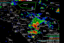
While very uncommon on the coastal strip, the North American Monsoon can bring occasional thunderstorms and high humidity to Greater Los Angeles in the summer and early fall.
Winters are mild to moderately warm, with average high temperatures at the Downtown/USC weather station of 68 °F (20 °C) and lows of 48 °F (9 °C), with occasional heavy rainfall.
The last severe cold outbreak in the Los Angeles area occurred in December 1990, when temperatures dropped below freezing across a major portion of the coastal plain and into the low to mid-20s °F over inland valleys.
Temperatures stayed below freezing for up to eight hours at some valley locations, resulting in significant damage to plants and commercial agriculture.
[23] In the winter months, high-pressure systems over the deserts often bring Santa Ana winds, resulting in dry, and dusty days.
However, this type of heat does not occur each December, and milder conditions in the mid-60s to low 70s °F are generally expected throughout the Los Angeles region.
Likewise, the "winter-season" temperature pattern of 65 to 75 °F (18 to 24 °C) highs and 45 to 60 °F (7 to 16 °C) lows may last through April or May, periodically interrupted by hot Santa Ana wind events for up to a week at a time.
June is a transitional month consisting of less volatile temperatures between 60 and 80 °F (16 and 27 °C) and increased cloudy days, as well as the disappearance of the Santa Ana winds.
Most cold fronts and depressions spun off by the polar low, the strong winter seasonal low-pressure area in the Gulf of Alaska, fail to carry significant precipitable moisture as far south as Los Angeles, resulting in the region's relatively low average rainfall amount of 12–15 inches (300–380 mm) even in normal years.
Some years, a well-developed series of cold fronts moves into the area with relatively short separation between each, bringing intermittently rainy periods to Los Angeles for several weeks at a time.
Other years, especially in the drought years of 2012–2016, a blocking region of atmospheric high pressure over the eastern Pacific Ocean, between Alaska and the Pacific Northwest, diverts the jet stream and its flow of cold fronts far to the north through Canada and down into the U.S. Midwest, leaving the U.S. west coast and especially Los Angeles under warm and dry conditions for weeks to months at a time.
Los Angeles averages only 14.7 inches (373 mm) of precipitation per year, and this is lower at the coast and higher in the mountains and foothill cities.
[27] Historically, the warm phase of an El Niño–Southern Oscillation (ENSO) regime typically coincides with above-average precipitation across Southern California.
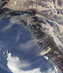
[31] The Los Angeles Basin, composed of the coastal plain surrounded by mountains, is generally the coolest in summer and mildest in winter.
Culver City, Inglewood, Palms, and surrounding areas are only a few miles inland from Santa Monica and the beach, but reach temperatures up to 10 degrees (F) warmer on average in the summer.
Culver City has a semi-arid climate that is still significantly moderated by the Pacific trade winds keeping averages mild compared to areas farther inland.
Canoga Park and Woodland Hills, in the south-west end of the valley, typically record the highest temperatures.
The city of Burbank, at the eastern end of the Valley, is also known for being significantly hotter than downtown Los Angeles, which is only 9 miles (14 km) to the south.
By comparison, Canoga Park has quite cool summer nights, in contrast to many other interior Southern California areas.
Since official records were first kept in 1877, the downtown Los Angeles weather station observed measurable snowfall three times, in 1882, 1932, and 1949.
They range from hot to cold, depending on the prevailing temperatures in the source region, the Great Basin and upper Mojave Desert.
These winds are notorious for causing hot, dry weather due to compressional heating of the lower atmosphere.
This atmospheric stability is largely due to the cool and persistent marine layer, which is fueled by the constant influx of cold Pacific water via the California Current.
Occasionally, these bring impressive displays of lightning, hail, and damaging winds to small localities within the region.