Climate of the Tampa Bay area
In general, the local communities farthest from the coast have larger temperature ranges, both during a single day and throughout the seasons of the year.
[6] In the typical summertime weather pattern, the combination of daytime heating and the interaction of the Gulf and Atlantic sea breezes creates thermal-fueled cumulus clouds over the Florida peninsula.
[5] These storms can form anywhere across Central Florida from the interior near Orlando to along the west coast, depending on the wind and local weather conditions.
Wherever they develop, Tampa's most common summer weather pattern results in afternoon thundershowers that usually rain themselves out by sunset, though on occasion, a storm cell will persist and drift west to the Gulf of Mexico to produce nighttime lightning displays visible from local beaches.
[3] A less common summer weather pattern is for prevailing westerly winds to cause overnight thundershowers to form offshore along a land breeze front.
These storms bring morning rain to the Tampa area before moving inland later in the day, reversing the more typical timing.
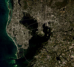
[7]) Waterspouts sometimes form when outflows from adjacent storm cells interact and begin to rotate over water, creating a funnel cloud over Tampa Bay or off the gulf beaches.
The local weather during these months is normally sunny, mild, and quite dry, with a general cooling trend through the fall and a slow increase in temperatures starting in February.
[18] According to The Weather Channel, Tampa's all-time record low temperature is 18 °F (−8 °C) and St. Petersburg's is 20 °F (−7 °C), both occurring during the same cold snap on December 13, 1962.
The historical averages late in the wet season are augmented by the passage of tropical cyclones, which can drop several inches of rain in just a few hours.
[21] The daily sunshine amount is highest in May, when the sun's angle of incidence brings more hours of daylight but the rainy season has not yet begun.
[21] June through November is hurricane season in the Atlantic Basin and Caribbean Sea, with the most tropical activity occurring between mid-August to mid-October.
[22] Rain dropped by tropical systems is an important component of the area's annual precipitation and is vital for replenishing the water supply of communities around Tampa Bay.
[29][30] Charley was forecast to make a direct hit on Tampa Bay from the south-southwest, which would have been the worst-case scenario for local storm surge flooding.