Climate of Nigeria
[2] Its rainfall is mediated by three distinct conditions including convectional, frontal, and orographical determinants.
[6] Nigeria's climate is influenced by its geographical location, topography, and the interactions of various air masses.
This climate generally has an estimated average annual rainfall of 2000mm[2] which varies for both the coastal areas and the inland regions.
The tropical savannah climate has a mean annual rainfall of about 1200mm or below, while the monthly mean temperature ranges from 22 °C (72 °F) during nighttime to 33 °C (91 °F) at daytime.
The dry season is accompanied by the dusty northeast winds where midday temperatures that can sometimes reach 100F (38C).
The wet season is particularly noticeable on the southeastern coast, where annual rainfall reaches about 130 inches (330 cm), where temperatures rarely exceed 90F (32C).
The average annual temperature ranges from 25 °C to 32 °C, with regional variations based on factors such as elevation and proximity to water bodies.
States in the northern part of the country are experiencing higher temperatures, lesser rainfalls and are threatened by drought, famine, and food scarcity.
[23] The northern part is more vulnerable to heat waves due to the hot semi-arid climate.
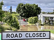
[24][25] The 2017 flooding that occurred during the rainy season in Benue state was another disaster that displaced a thousand people.
[26] In 2021, 32 out of Nigeria's 36 states had cases of flooding according to the National Emergency Management Agency, reporting 155 lives lost between August and October.
[28] Prolonged drought in Nigeria has led to desertification and land scarcity for farming and livestock.
Satellite images from NASA reveal severe desertification, affecting about 900,000 km2 of savanna grassland between the 1960s and 1986.
Drought is a recurring issue in Nigeria, particularly in the arid north, with historical famines documented in various years.
A recent survey by SBMIntel found that 79% of Nigerian farmers were impacted by drought and flooding in 2020, with 26.3% experiencing significant harvest disruptions.