Geography of Nigeria
It shares land borders with the Republic of Benin to the west, Chad and Cameroon to the east, and Niger to the north.
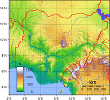
The country's most elevated point is Chappal Waddi (or Gangirwal) at 2,419 metres or 7,936 feet, situated in the Adamawa mountains in the Gashaka-Gumti Public Park, Taraba State, on the border with Cameroon.
[5] This climate is influenced by the monsoons originating from the South Atlantic Ocean, which are brought into the country by the (maritime tropical) MT air mass, a warm moist sea-to-land seasonal wind.
Its warmth and high humidity gives it a strong tendency to ascend and produce copious rainfall, which is a result of the condensation of water vapour in the rapidly rising air.
[8] The tropical savanna climate, characterized by distinct rainy and dry seasons, dominates western to central Nigeria.
With the Intertropical Convergence Zone swinging northward over West Africa from the Southern Hemisphere in April, heavy showers coming from pre-monsoonal convective clouds mainly in the form of squall lines also known as the north easterlies formed mainly as a result of the interactions of the two dominant airmasses in Nigeria known as the maritime tropical (south westerlies) and the continental tropical (north easterlies),[10] begins in central Nigeria while monsoons arrive in July, bringing with it high humidity, heavy cloud cover and heavy rainfall lasting until September when the monsoons gradually begin retreating southward to the southern part of Nigeria.
As one moves northward and eastward, annual rainfall declines steadily to around 650 millimetres or 26 inches at Sokoto in the northwest and as low as 400 millimetres or 16 inches in the extreme north of Yobe and Borno States, which under the sweltering conditions that prevail is dry enough to be a hot arid climate (Köppen BWh).
[13] High temperatures and increased insolation cause low pressure in West Africa and Nigeria between March and May.
The Saharan continental air mass weakens due to land surface overheating, causing the atmosphere to expand and become lighter.
Nigeria's dry season from December to March is dominated by a dusty tropical continental air mass, which creates a haze and hinders visibility.
The Sun shines through the atmosphere with little obstructions from the clear skies making the dry season in Nigeria a period of warmer weather conditions.
In the middle of the dry season around December, the dust brought in by the Harmattan partially blocks the sun's rays, which lowers temperatures.
But with the withdrawal of this wind around March to April following the onset of the rainy season, temperatures can go as high as 44 °C (111.2 °F) in some parts of Nigeria.
[20] Semi-temperate weather conditions prevail on the highlands in central Nigeria above 1,200 metres (3,937 ft) above sea level, namely the Jos Plateau.
Time and Date (dewpoints, 2005-2015)[24] Weather Atlas (daily sun hours)[25] Nigeria's most expansive topographical region is that of the Niger and Benue River valleys, which merge into each other and form a "y" shaped confluence at Lokoja.
To the southwest of the Niger there is "rugged" highland, and to the southeast of the Benue hills and mountains are found all the way to the border with Cameroon.
The mangrove swamps are vegetated tidal flats formed by a reticulate pattern of interconnected meandering creeks and tributaries of the Niger River.
In 2004, the IUCN–World Conservation Union identified 81 IAS in South Africa, 49 in Mauritius, 37 in Algeria and Madagascar, 35 in Kenya, 28 in Egypt, 26 in Ghana and Zimbabwe, and 22 in Ethiopia.
[48] The initial entry of IAS into Nigeria was mainly through exotic plant introductions by the colonial rulers either for forest tree plantations or for ornamental purposes.
[48] In the semi-arid and dry sub-humid savannas of West Africa, including Nigeria, numerous species of herbaceous dicots especially from the genera Crotalaria, Alysicarpus, Cassia and Ipomea are known to be widely used in livestock production.
[46] Many other species native to Nigeria, including soybean and its varieties, serve as an important source of oil and protein in this region.
Different stress factors such as droughts, low soil nutrients and susceptibility to pests have contributed to Maize plantations being an integral part of agriculture in this region.
[50] As industrialization has increased, it has also put species of trees in the forest at risk of air pollution and studies have shown that in certain parts of Nigeria, trees have shown tolerance and grow in areas that have a significant amount of air pollution[51] Nigeria's natural resources include but are not limited to petroleum, tin, columbite, iron ore, coal, limestone, lead, zinc, natural gas, hydropower, and arable land.