Climate of North Carolina
The climate of North Carolina varies considerably from the Atlantic coast in the east to the Appalachian Mountains in the west.
The mountains often act as a "shield", blocking low temperatures and storms from Canada and the Midwest from entering the Piedmont and Coastal Plain of North Carolina.
The town of Boone, North Carolina, located at an elevation of 3,333 feet in the northwestern part of the state, receives on average nearly 25 inches (635 mm) of snowfall annually.
If the cyclones travel close to the coast, warm air will get pulled into eastern North Carolina due to increasing flow off the milder Atlantic Ocean, bringing a rain/snow line well inland with heavy snow restricted to the Piedmont, foothills and mountains, as with the January 22, 1987, storm that dropped 6 inches at Charlotte.
In 2024, North Carolina was severely impacted by Hurricane Helene, primarily in its western Appalachian region, causing over 100 reported deaths and significant destruction of infrastructure and residential areas across multiple counties.
[19] After making landfall in the Big Bend region of Florida on September 27, the hurricane began to traverse over land across Georgia as a Category 2 hurricane[20] and into the Appalachian mountain range as a strong tropical storm, bringing record rainfall to dozens of communities in western North Carolina, including Asheville, Boone, Chimney Rock, Lake Lure, Lansing, Montreat, and Swannanoa.
According to meteorologist Ben Noll, Hurricane Helene released nearly 1.5 times more moisture in western North Carolina than in any prior previous recorded event in the region, with an estimated integrated vapor transport quantity of ~3,000 kilograms per meter per second.
[23] Heavy rains accompany tropical cyclones and their remnants which move northeast from the Gulf of Mexico coastline, as well as inland from the western subtropical Atlantic Ocean.
Over the past 30 years, the wettest tropical cyclone to strike the state was Hurricane Florence in September 2018, which dropped over 35 inches (890 mm) of rainfall northwest of Elizabethtown.
This saturated much of the western North Carolina soil and allowed heavy rains from Hurricane Floyd to turn into floods.
[16] In the mountains, Hurricane Frances of September 2004 was nearly as wet, bringing over 23 inches (580 mm) of rainfall to Mount Mitchell.
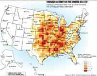
[24] In most years, the greatest weather-related economic loss incurred in North Carolina is due to severe weather spawned by summer thunderstorms.
These storms affect limited areas, with their hail and wind accounting for an average annual loss of over US $5 million.
While the severe weather season usually spans from March to May, tornadoes have touched down in North Carolina in every month of the year.
[26] On November 28, 1988, an early morning F4 tornado smashed across northwestern Raleigh, continuing 84 miles further, killing 4 and injuring 157.
[28] By 4:00 PM local time, 100,000 people were without power and flash flood warnings were in effect for much of the area due to heavy rainfall.
[28] The North Carolina coastline is expected to rise between one and four feet in the next century due to a combination of warming oceans, melting ice, and land subsidence.
Over the last 100 years, the average temperature in Chapel Hill has gone up 1.2 °F (0.7 °C) and precipitation in some parts of the state has increased by 5 percent.
However, occasionally cold air can move from the north or northeast, east of the Appalachian Mountains, from Arctic high pressure systems that settle over the Northeastern or New England states.
Other polar and Arctic outbreaks can cross the mountains and force temperatures to drop to about 12 °F (−11 °C) in central North Carolina.
The winter temperatures on the coast are milder due to the warming influence of the Atlantic Ocean and the Gulf Stream.
The Appalachian Mountains are frequently visited at this time of year, due to the leaves changing color in the trees.