Cloud
This is an accepted version of this page In meteorology, a cloud is an aerosol consisting of a visible mass of miniature liquid droplets, frozen crystals, or other particles, suspended in the atmosphere of a planetary body or similar space.
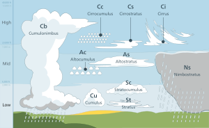
Genus types in the troposphere, the atmospheric layer closest to Earth's surface, have Latin names because of the universal adoption of Luke Howard's nomenclature that was formally proposed in 1802.
In the case of stratocumuliform clouds, the prefix strato- is applied to the low-level genus type but is dropped from the mid- and high-level variants to avoid double-prefixing with alto- and cirro-.
Around 340 BC, Greek philosopher Aristotle wrote Meteorologica, a work which represented the sum of knowledge of the time about natural science, including weather and climate.
[10]After centuries of speculative theories about the formation and behavior of clouds, the first truly scientific studies were undertaken by Luke Howard in England and Jean-Baptiste Lamarck in France.
[11] As a sign of the popularity of the naming scheme, German dramatist and poet Johann Wolfgang von Goethe composed four poems about clouds, dedicating them to Howard.
[17] Frontal and cyclonic lift occur in the troposphere when stable air is forced aloft at weather fronts and around centers of low pressure by a process called convergence.
However, water vapor that has been lifted to the top of troposphere can be carried even higher by gravity waves where further condensation can result in the formation of clouds in the stratosphere and mesosphere.
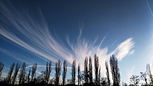
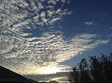
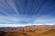
Stratocumuliform and stratiform clouds in the high altitude range carry the prefix cirro-, yielding the respective genus names cirrocumulus (Cc) and cirrostratus (Cs).
[43] These clouds have low- to mid-level bases that form anywhere from near the surface to about 2,400 m (8,000 ft) and tops that can extend into the mid-altitude range and sometimes higher in the case of nimbostratus.
Unlike less vertically developed clouds, they are required to be identified by their standard names or abbreviations in all aviation observations (METARS) and forecasts (TAFS) to warn pilots of possible severe weather and turbulence.
[9] Genus types are commonly divided into subtypes called species that indicate specific structural details which can vary according to the stability and windshear characteristics of the atmosphere at any given time and location.
The species castellanus appears when a mostly stable stratocumuliform or cirriform layer becomes disturbed by localized areas of airmass instability, usually in the morning or afternoon.
[81] Castellanus resembles the turrets of a castle when viewed from the side, and can be found with stratocumuliform genera at any tropospheric altitude level and with limited-convective patches of high-level cirrus.
The full technical name of a cloud in this configuration would be altocumulus stratiformis radiatus perlucidus, which would identify respectively its genus, species, and two combined varieties.
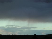
Virga is a feature seen with clouds producing precipitation that evaporates before reaching the ground, these being of the genera cirrocumulus, altocumulus, altostratus, nimbostratus, stratocumulus, cumulus, and cumulonimbus.
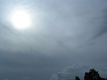
[93] This normally occurs with altostratus opacus, which can produce widespread but usually light precipitation, and with thicker clouds that show significant vertical development.
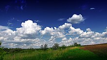
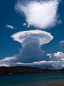
Of the latter, upward-growing cumulus mediocris produces only isolated light showers, while downward growing nimbostratus is capable of heavier, more extensive precipitation.
Towering vertical clouds have the greatest ability to produce intense precipitation events, but these tend to be localized unless organized along fast-moving cold fronts.
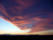
The feature fluctus can form under conditions of strong atmospheric wind shear when a stratocumulus, altocumulus, or cirrus cloud breaks into regularly spaced crests.
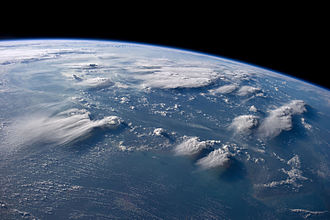
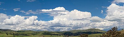
It is most prevalent in and along low pressure zones of surface tropospheric convergence which encircle the Earth close to the equator and near the 50th parallels of latitude in the northern and southern hemispheres.
[108] Near the equator, increased cloudiness is due to the presence of the low-pressure Intertropical Convergence Zone (ITCZ) where very warm and unstable air promotes mostly cumuliform and cumulonimbiform clouds.
[110] This leads to the formation of weather-making extratropical cyclones composed of cloud systems that may be stable or unstable to varying degrees according to the stability characteristics of the various airmasses that are in conflict.
High thin tropospheric clouds reflect less light because of the comparatively low concentration of constituent ice crystals or supercooled water droplets which results in a slightly off-white appearance.
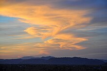
[117] During daytime when the sun is relatively high in the sky, tropospheric clouds generally appear bright white on top with varying shades of gray underneath.
Since a green/blue tint signifies copious amounts of water, a strong updraft to support it, high winds from the storm raining out, and wet hail; all elements that improve the chance for it to become severe, can all be inferred from this.
All of these effects are subtly dependent on the vertical temperature and moisture structure of the atmosphere and result in major redistribution of heat that affect the Earth's climate.
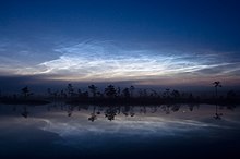
[133] Ongoing research indicates that convective lift in the mesosphere is strong enough during the polar summer to cause adiabatic cooling of small amount of water vapor to the point of saturation.
Because of the need for maximum cooling of the water vapor to produce noctilucent clouds, their distribution tends to be restricted to polar regions of Earth.
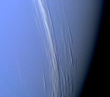
[154][155] The Cassini–Huygens Saturn mission uncovered evidence of polar stratospheric clouds[156] and a methane cycle on Titan, including lakes near the poles and fluvial channels on the surface of the moon.