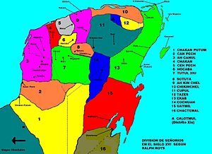
Cochuah
The cacicazgo bordered with Cupul in the north, with Sotuta, Tutul Xiu and Chakán Putún in the west, and with Ekab and Uaymil in the east, according to the map made by Ralph L. Roys.
Some authors, like Héctor Pérez Martínez in his notes for the seventh edition (1938) of The Report of the Affairs of Yucatan by Diego de Landa says that the capital of Cochuah was Tixhotzuc, citing Juan Francisco Molina Solís.
However, according to Yucatan at the Time, Chunhuhub (today in the municipality of Felipe Carrillo Puerto, Quintana Roo) seems to have been the main city, much closer to the province of Uaymil.
Other than that city, to the east and the south extended great forests with little population up to the Bay of Ascension, which some writers consider formed part of the jurisdiction of Cochuah.
Recently, there has been archaeological work exploring Yo'okop, a site which appears to have had importance during the post-classical period and long after, in the 19th century as epicenter of the class war during which rebellious natives took refuge in this region of the Yucatán peninsula.