Coldrum Long Barrow
As with other barrows, Coldrum has been interpreted as a tomb to house the remains of the dead, perhaps as part of a belief system involving ancestor veneration, although archaeologists have suggested that it may also have had further religious, ritual, and cultural connotations and uses.
After the Early Neolithic, the long barrow fell into a state of ruined dilapidation, perhaps experiencing deliberate destruction in the Late Medieval period, either by Christian iconoclasts or treasure hunters.
[9] Environmental data from the vicinity of the White Horse Stone, a putatively prehistoric monolith near the River Medway, supports the idea that the area was still largely forested in the Early Neolithic, covered by a woodland of oak, ash, hazel/alder and amygdaloideae.
[10] Throughout most of Britain, there is little evidence of cereal or permanent dwellings from this period, leading archaeologists to believe that the island's Early Neolithic economy was largely pastoral, relying on herding cattle, with people living a nomadic or semi-nomadic life.
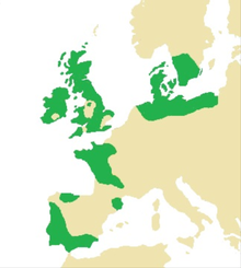
[15] These chambered tombs were built all along the Western European seaboard during the Early Neolithic, from southeastern Spain up to southern Sweden, taking in most of the British Isles;[16] the architectural tradition was introduced to Britain from continental Europe in the first half of the fourth millennium BCE.
[18] Although now all in a ruinous state and not retaining their original appearance,[19] at the time of construction the Medway Megaliths would have been some of the largest and most visually imposing Early Neolithic funerary monuments in Britain.
[2] The megalithic builders responsible for the Coldrum Stones positioned it on the top of a small ridge adjacent to the North Downs, and constructed it facing eastward, towards the River Medway.
[2] It is located on the edge of a large lynchet scarp,[46] although it is difficult to ascertain what views would have been possible from the monument at the time of construction, due to a lack of information on how densely forested the vicinity was.
[51] Excavation has revealed that flint masonry was used to pack around the chamber and support its sarsens; 20th-century renovation has seen this largely replaced with cement, allowing the stones to continue standing upright.
[15] Archaeologists have suggested that this is because Early Neolithic Britons adhered to an ancestor cult that venerated the spirits of the dead, believing that they could intercede with the forces of nature for the benefit of their living descendants.
[72] The osteoarchaeologists Martin Smith and Megan Brickley cautioned that this did not necessarily mean that all of the individuals in any given barrow were members of a single family group, for such shared cranial traits would also be consistent with "a population that was still relatively small and scattered", in which most people were interrelated.
Although this data is difficult to interpret, the investigative team believed that it probably reflected that these individuals had had a terrestrial diet high in animal protein that over time was increasingly supplemented with freshwater river or estuarine foods.
He believed that the kerb-stones around the barrow were toppled, laid prostrate in the surrounding ditch, and then buried during the late 13th or early 14th century, by Christians seeking to obliterate non-Christian monuments.
[85] Alexander believed that the destruction in Kent may have been brought about by a special commissioner, highlighting that the "expertness and thoroughness of the robbery" at Chestnuts would have necessitated resources beyond that which a local community could probably muster.
[55] In a 1946 paper, the folklorist John H. Evans recorded the existence of a local folk belief that a battle was fought at the site of the Coldrum Stones, and that a "Black Prince" was buried within its chamber.
[87] Evans also recorded a local folk belief applied to all the Medway Megaliths and which had been widespread "up to the last generation"; this was that it was impossible for anyone to successfully count the number of stones in the monuments.
In the late 1990s, the South London branch of the Paganlink organisation held a ritual at the Coldrum Stones in an unsuccessful attempt to prevent the construction of the Channel Tunnel Rail Link through the Medway Valley landscape.
[101] Another politically motivated Pagan rite was carried out there in the early 2010s by The Warrior's Call, a group seeking to prevent fracking in the United Kingdom by invoking "the traditional spirits of Albion" against it.
[105] There are claims that at the start of the 19th century, the Reverend Mark Noble, Rector of Barming, prepared a plan of the site for Gentleman's Magazine, although no copies have been produced to verify this.
[107] Associating the site with the druids of Britain's Iron Age, Poste's suggestion was that the name "Coldrum" derived from the linguistically Celtic "Gael-Dun", and that Belgic chiefs were interred there.
[110] He further added that "it is a tradition of the peasantry that a continuous line of stones ran from Coldrum direct to the well-known monument called Kit's Cotty [sic] House", attributing this belief to various megaliths scattered throughout the landscape.
"[116] Payne also noted a folk tradition that there were stone avenues connecting Coldrum to the Addington Long Barrow, but added that he was unable to discover any physical evidence of this feature.
[128] In 1904, George Clinch published a note on the Medway Megaliths in the Royal Anthropological Institute's journal, Man, in which he referred to the Coldrum Stones as "at once the most remarkable and the least known of the whole series.
"[129] Suggesting that its design indicates that it was built during "a late date in the neolithic age",[130] he compared the workmanship in producing the megaliths to that at Stonehenge, although noted that they differed in that the Coldrum Stones clearly represented "a sepulchral pile".
[131] In that same issue, Lewis included an added note in which he rejected the idea that the monument had once been covered by an earthen tumulus because he could see "no evidence that anything of that kind ever existed", and instead he interpreted the site as a stone circle, comparing it to the examples at Avebury, Arbor Low, and Stanton Drew, suggesting that the central chamber was a shrine.
[132] He returned to the site for further excavation in August 1910, this time with his niece and her husband, both of whom were dentists with an interest in craniology; on that day they discovered pieces of a human skull, which they were able to largely reconstruct.
[34] "Some young man was selected, one of a family perhaps set apart, and had a very merry time during his year of god-ship, at the end of this, he was sacrificed at the dolmen [chamber], being led up the ascent, and his body was dismembered and the limbs and blood scattered over the fields to ensure fertility.
[138] Their project was financed through grants provided by the British Association and the Society of Antiquaries,[139] with Filkins noting that at the time of its commencement, "a miniature jungle" had grown up around the site which had to be cleared.
[1] A plaque was erected to mark this, which erroneously termed the monument a stone circle;[143] in 1953, the archaeologist Leslie Grinsell expressed the view that "it is hoped that this error may be rectified in the near future".
[147] A patch of scorched earth exists on the grass in the centre of the monument, perhaps used by Pagans as well as non-Pagans, and the Trust warden responsible for the site has decided to leave it there rather than seeding it over, in order to encourage any who do light fires to do so in the same spot rather than nearer to the stones themselves.