Colstrip, Montana
[4] The entire community celebrates Colstrip Days annually on the weekend prior to the 4th of July.
Colstrip was established by the Northern Pacific Railway in 1924 as a company town to provide coal for their steam locomotives.
[5][6] During The Second World War, the Colstrip mine was identified as strategically important because it supplied coal for the Northern Pacific Railway steam locomotives hauling military equipment for the war effort.
In 1974, construction of Colstrip's 150-acre (0.61 km2) Castle Rock Lake (formerly named surge pond) was completed.
The water for the steam is pumped in an underground pipe 30 miles (48 km) from the Yellowstone River and stored in the lake.
Located six miles (10 km) north of Colstrip, this experimental electricity production facility is owned by Rosebud Energy Corp., a partnership that at one point included Enron.
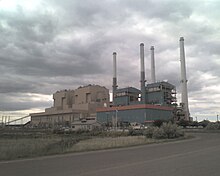
In June 2015, PPL spun off its power generation assets including the Colstrip plants to become Talen Energy.
In 2016, Puget Sound Energy reached an agreement with the Sierra Club and the Montana Environmental Information Center to shut down units 1 and 2 of the coal-fired generating plant by the year 2022.
[15] Another blow to Colstrip's economy came when a proposed junction point from BNSF Railway to connect to Tongue River Railroad was dismissed.
[16] In June 2019, Talen Energy announced the closure of two of the four coal burning units by the end of the year.
The power plant is "the sixth-largest source of greenhouse emissions in the U.S."[17] Units 3 and 4 will remain in operation.
[19] In January 2023, Avista made a deal giving NorthWestern Energy their 15% share of the plant for free.
A Washington state law bans use of coal-generated electricity, forcing Avista to relinquish their stake in the company.
According to the United States Census Bureau, the city has a total area of 4.47 square miles (11.58 km2), all land.
South of town 23 miles (37 km), is Deer Medicine Rocks, a National Historic Landmark.
Colstrip is about 20 miles (32 km) north of the Northern Cheyenne Indian Reservation.
Boating and fishing is available on Castle Rock Lake, an artificial reservoir used by the Colstrip power plants.
A 3.2 mile walking/biking trail runs around the lake, and a picnic area and beach is available to swimmers.
CPRD, formerly CARPA, offers sports programs for children and adults alike including golf,[38] soccer, basketball, baseball, fitness and health classes.
[41] The Forsyth-based Independent Press covers news for all of Rosebud County, which includes Colstrip.