Columbus, Kentucky
It was first settled on the Mississippi floodplain in 1804 and known as "Iron Banks" after the site's French name les rivages de fer.
[2] The long-held local rumor that President Thomas Jefferson planned to remove the American capital to the site[3][4] has absolutely no basis in fact.
[5] In 1861, after the American Civil War broke out, the town was seized by Confederate forces (including the Louisiana "Shreveport Rebels".
[6]) Confederate general Leonidas Polk tried to run and maintain a large anchor chain across the entire Mississippi at Columbus in order to block Union traffic downriver.
The Union responded by General Ulysses S. Grant's engaging the Confederates at Belmont on the Missouri shore.
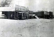
[7] Given its isolated location in a rural area and the decline in river traffic, the town has lost population for years.
Columbus is located in northwestern Hickman County at 36°45′37″N 89°6′10″W / 36.76028°N 89.10278°W / 36.76028; -89.10278 (36.760176, -89.102840),[8] on high ground 0.6 miles (0.97 km) east of the Mississippi River.
Kentucky Route 58 leads southeast from Columbus 9 miles (14 km) to Clinton, the county seat.
According to the United States Census Bureau, the city has a total area of 0.3 square miles (0.8 km2), all land.