Columbus Basin
Due to the intensive deformation occurring along the Caribbean and South American plates in this region, the basin has a unique structural and stratigraphic relationship.
[1] The area has also been extensively deformed by series of north west to southeast normal faults and northeast to southwest trending anticline structures.
[2] The Columbus Basin makes up the eastern section of the EVB, occurring along the South American and Caribbean obliquely convergent plate margins.
[3] According to Garciacaro et al.,[2] the foreland basin was created by flexural subsidence at the passive margin of the colliding regions of the Caribbean and South American plates.
[1] The Columbus basin is bounded by the Darien Ridge, part of the uplift region in the north west, which separates the thrusted area from the extended section to the southeast.
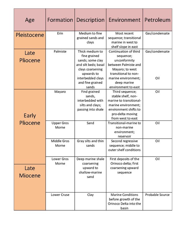
[3] Based on the correlations presented in the paper by Leonard in 1983, the main stratigraphic units found overlying the Cretaceous shales in the Columbus basin are the Gros Morne, Mayaro, Palmiste and Erin Formation.
The Upper Gros Morne consists of a reservoir of the Columbus basin as this sedimentary unit is composed mostly of sand deposited in transitional-marine to terrestrial environment.
In the western part of the basin, the Mayaro Formation shifts from thick fine grained sands with alternating layers of silts and clays to a predominantly shale pro-delta unit.
In the western part of the basin, there are thick, medium to fine grained sands with some interbedding with clay and silt, deposited in transitional-marine to terrestrial environment.
[3] Currently, in the early Holocene, subsidence or possibly sea level rise of 100–200 feet contributed to deposits of a middle to outer neritic zone environment.
The regional extension that occurred as a result of the collision of Caribbean and South American plates was enhanced with the failure of normal faults due to the loading caused by increased sedimentation.
[2] The generation of petroleum from the Lower Cruse formation is said to be of type II kerogen that is characterized by high oil to gas ratios.
[5] The NE-SW trending extensional faults that developed as a result of the convergent margin and loading provide pathways for the movement of the hydrocarbon from the Miocene shales to the fluvio-deltaic Orinoco Delta sands of the Pliocene-Pleistocene.
[5] The anticline structures that formed as the basin extended and with the activation of normal faults as sediment load increased, act as traps for the hydrocarbons.