Coma Pedrosa
Coma Pedrosa (Catalan pronunciation: [ˈkomə pəˈðɾozə]; 2,943 m or 9,656 ft) is the highest mountain in the principality of Andorra.
[3] Nowadays, the mountain is part of the Parc Natural Comunal de les Valls del Comapedrosa national park.
[7] Coma Pedrosa is classified as a subalpine climate (Dfc), due to fewer than 4 months with an average temperature above 10°C (50°F).
The trek or the mountain climb starts from Arinsal, which is considered an easy route, from the picnic area at the base of the Ribal Warefall at 1,580 metres (5,180 ft).
The first part of the climb, taking just under half an hour, is along a wide, 800 metres (2,600 ft) long foot track past a signpost to Aigues Juntes, which is the confluence of the Coma Pedrosa River and Pla de l'Estany River rising from the mountains and arriving at Grau.
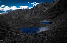
The ascent continues along a steep hill slope of the Coma Pedrosa River valley and arrives at the Coma Pedrosa refuge or camping site at an elevation 2,272 metres (7,454 ft), which is located near the l'Estany de les Truites (Trout Lake).
The last stretch is for about one hour from Estany Negre to the highest peak in Andorra at 2,943 metres (9,656 ft) elevation, and this trek, passing through rocky terrain, is difficult.