Comala
[2][3] The area was originally called Ajuchitlán or Valley of the Flowers with indigenous settlements located near water flowing down from the Colima Volcano .
[2] The main road through the municipality is a four lane boulevard that extends from Villa de Alvarez for a length of 6.5 km.
It is dedicated to the community history and indigenous identity and includes agrarian implements and documents, arms from the Mexican Revolution, pieces of the old railroad and testimonies from the Cristero War.
[2] Local religious festivals include the feast of the Virgin of Candelaria in Suchitlán on 2 February, Saint James on 25 January and Isidor the Laborer on 15 May in Zacualpan.
The opening ceremony features people with crowns and scepters made of bread, flowers and necklaces who give solemn and emotional speeches.
[6] Many of the older buildings, especially in the town center have walls made of adobe, and many of the houses have small yards with flowers guarded by iron fences.
[5] In the center of the plaza, there is a white kiosk with a stone base topped with a metal roof structure, manufactured in the early 20th century.
[7] Surrounding the kiosk are garden areas with palm trees and rose bushes, four fountains in each of the corners and Gothic style iron benches created by Alejandro Rangel Hidalgo.
This includes a dish called tatemado, which is pork in a thick sauce made with guajillo chili peppers, as well as pozole and white menudo .
It has been made for generations in Comala with at least twenty families currently involved in its production although there are thought to be more who produce it clandestinely.
The drink has been given a certification of the name so that products called “ponche de Comala” must be from the area, similar to tequila.
[7] Comala was named a Pueblo Mágico in 2002 and in 2006 on it has invested about ten million pesos in projects to promote the town image for tourism.
[10] The town hosted the 2011 convention of Mexico's forty Pueblos Mágicos to exchange ideas of how to increase tourism.
[11] Its main tourist attractions are the "Alejandro Rangel Hidalgo" and the "Eco park", of the University of Colima, as well as the same "Ex hacienda de Nogueras", famous for its "chacuaco" of the extinct sugar mill.
The Nogueras eco-park is dedicated to the preservation of flora and fauna research in the region, where you can see medicinal plants, fruit trees and compost, an area where the use of alternative energy is shown, recycling workshops and environmental training .
[5][4] By 1873, the hacienda was bankrupt and eventually sold to the Rangel family, who ran the sugar cane mill until the Mexican Revolution.
Another section of the museum is dedicated to local pre Hispanic ceramics, mostly funerary offerings from shaft tombs.
[4] Upon his death, Rangel donated the hacienda to the University of Colima, allowing the art and the pre-Hispanic artifact to remain on the land on which they were created.
The complex is called the Centro Cultural Nogueras with the main house dedicated as the Alejandro Rangel Hidalgo Museum.
[7] Zacualpan It is an indigenous community on the slopes of Cerro Grande, on the edge of the ravine that has carved the Armería River in the sand and rock deposits thrown by the Volcán de Fuego.
It is perhaps also the only case of survival of the ancient tradition of the "cacicas", reason that several towns in the region bears the name of Cihuatlán, "place of women", which made Hernán Cortés believe that he had discovered the mythical land of the Amazons.
It is an indigenous community on the slopes of Cerro Grande, on the edge of the ravine that has carved the Armería River in the sand and rock deposits thrown by the Volcán de Fuego.
It is perhaps also the only case of survival of the ancient tradition of the "cacicas", reason that several towns in the region bears the name of Cihuatlán, "place of women", which made Hernán Cortés believe that he had discovered the mythical land of the Amazons.
There are exhibited archaeological objects of the region, photographs and historical documents of the town, carbines 30-30 and other weapons of the Revolution and the Cristero War, as well as some pieces and sections of rail of the narrow track train that installed the company Colima Lumber Company to exploit the forest wealth of Cerro Grande.
Photographs and personal belongings of the most famous personage of the town, Vicente "El Indio" Alonso, are also exhibited.
[2] The natural vegetation of the area is low growth rainforest with some species that lose their leaves in the dry season.
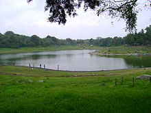
It contains emblematic images related to the municipality such as the volcano, a walnut tree, the former hacienda of San Antonio, the Carrizalillos Lake, a glyph for a comal and the ceramic dog figures that characterize Colima.
Other crops include tomatillos, rice, green chili peppers, beans, cucumbers, jicama, limes, mangos, tamarind, avocados, mamey and guava.
Handcrafts include baskets, carved wooden masks for traditional dances, palm frond hands, tarrallas, chiquihuites and comals.
[5] The El Remate reserve is part of a project to protect the cultural history and ecology of the area while promoting it for tourism.