Communipaw
[2] It is located west of Liberty State Park and east of Bergen Hill,[3][4] and the site of one of the earliest European settlements in North America.
It gives its name to the historic avenue which runs from its eastern end near Liberty State Park Station through the neighborhoods of Bergen-Lafayette and the West Side that then becomes the Lincoln Highway.
Communipaw Cove at Upper New York Bay, is part of the 36-acre (150,000 m2) state nature preserve in the park and one of the few remaining tidal salt marshes in the Hudson River estuary.
Whitlock Cordage[10] is an intact complex of industrial buildings built in the Lafayette section along the long ago filled Morris Canal.
[13] Ficken's Warehouse, once the site of Bergen City's main post office, is on the National Register of Historic Places listings in Hudson County, New Jersey.
At the time of European settlement in the 17th century, Communipaw was the site of the summer encampment and council fire of the Hackensack Indians,[14] a phratry of the Lenape.
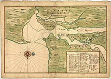
"[23] In 1634 one of the first "bouweries", or homesteads, in the colony of New Netherland was built at Communipaw as part of Pavonia, a patroonship of Amsterdam businessman Michiel Pauw.
[36][37] After the last English takeover of New Netherland in 1674 it became part of the Province of New Jersey, in the county of Bergen, though it retained its Dutch character for hundreds of years.
[39] Originally, the waters of the Upper New York Bay facing the village (situated near the site of today's Liberty Science Center) hosted vast oyster beds that were harvested well into the 19th century.