Comoro River
[7]: 5 Immediately to the west of the mouth is Presidente Nicolau Lobato International Airport,[3]: 36 and to its east is the Bay of Dili, of which it is the western end.
[11]: 3-6–3-76 During Timor-Leste's rainy season, the river's lower reaches are prone to flooding and consequent damage to infrastructure and housing.
[13][16][17] Both before and since Timor-Leste resumed independence in 2002, the river's flood-prone channels in Dili have been improved and provided with revetments or riverbank protection.
[5]: 2–3 In April 2005, the Ministry of Agriculture, Fisheries, and Forestry appointed the Japan International Cooperation Agency (JICA) to develop a community-based integrated watershed management plan for the Laclo and Comoro River basins.
Amongst other things, the plan proposed the construction of a flood control reservoir upstream of Dili to reduce the peak flow at the river mouth over a 50-year return period.
[27] According to the United Nations Office for Disaster Risk Reduction (UNDRR), the Cyclone Seroja flooding affected 13 municipalities and 30,322 households throughout Timor-Leste, destroyed 4,212 houses, took 34 lives, and was "... said to be the worst the country has seen in 50 years ...".
[28] The country manager of Australian People for Health, Education and Development Abroad (APHEDA) attributed it to the obstruction of waterways by housing erected along them.
[29] It has a total area of approximately 30,000 ha or 300 km2 (120 sq mi), and extends over four municipalities, namely Dili, Aileu, Ermera, and Liquiçá.
[30]: 9, 52 [31] Upstream of Dili's urban zone, the Comoro River catchment is formed by two valleys surrounded by steep mountains.
[6]: 2 There has been forest degradation in the catchment, mainly due to illegal cutting, firewood collection, wild fires and cattle grazing.
Phyllites in the catchment (between the central mountains at an elevation of about 1,000 m (3,300 ft) AMSL and the river mouth at sea level) are somewhat geologically fragile, and are easily eroded on being exposed to air after surface soil removal.
The vegetable types produced include mustard, cabbage, tomato, pumpkin, carrot, cucumber, snow pea, and spinach.
Additionally, Siam weed (Chromolaena odorata), a species poisonous to cattle, had invaded the catchment and reduced the availability of land viable for grazing.
[2]: iv, 5–10 However, more recent studies have concluded that development activities in the catchment area were placing stress on the aquifer by limiting the recharge.
Many of the north coast fishers fish part time or seasonally, and are otherwise occupied in additional activities such as carpentry, labouring or security work.
Most of their fish landings are of small pelagic species, including short-bodied mackerel, sardines (Clupeidae), halfbeaks and scads (Carangidae).
Catches of these pelagic species varied moderately between years, and were larger during the rainy season and when medium-sized turbid plumes were extending from the river mouth.
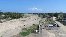
[32] In the lower reaches of the river, which have large and thick alluvium deposits, there is active small-scale artisanal mining excavation of gravel and sand.
[11]: 2–34, 2–35 The report also asserted that the sand and gravel mining was considered to be the cause of increased turbidity, suspended solids and other pollutants in the river water.