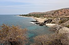
Ombai Strait
[5] Meanwhile, Ombai Strait continues to run from longitude 125° East in a south westerly direction, now within the limits of the Savu Sea.
The archipelago is the only interocean connection on earth at low latitudes, and the exchange of water between the two oceans is known as the Indonesian Throughflow (ITF).
[12] The ITF currents are at their weakest during the north-east monsoon rainy season (December–February), when there are also strong westerly (onshore) winds and waves.
[2] Along the northern littoral of Timor-Leste, including the strait, the shallow coastal waters are dominated by a seagrass bed about 2,200 ha (5,400 acres) in total area.
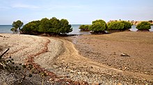
However, the country's mangrove cover has very substantially declined since 1940, and in Ombai Strait is now confined to the coastline and hinterland between Tibar [de] and the Bay of Dili.
[16]: 2, 8 The report of another survey, carried out in 2017, stated that the dominant species in the area was Sonneratia albia, and that there were some clusters of Rhizophora apiculata, Ceriops tagal, and Lumnitzera.
[15]: 7, 13–14, 22–23 In parts of Ombai Strait, and especially close to the coast of Alor Island, elevated phytoplankton blooms or concentrations (and therefore availability of food for other species) have been observed, particularly during the dry south-east monsoon.
[2][4] The physical structure of the strait makes it likely that such concentrations are driven by fronts and vertical flows caused by some combination of tidal currents or topographic effects.
[4] A study published in 2002 noted persistent flow-induced upwelling and frontal features in the strait, together with subjective evidence of extremely strong tides.
The study concluded that the upwelling and frontal features coincided with large phytoplankton blooms and significantly affected the concentration and distribution of chlorophyll in the Savu Sea.
[19] Other species that have been observed consistently in the strait include false killer whales (Pseudorca crassidens), and spinner dolphins (Stenella longirostris), both of them in huge pods made up of large numbers of individuals.
[17] A short distance further east, at Tasitolu, dugongs are often observed, although as of 2019[update] detailed information regarding their habitat location, size, and characteristics in the area was not available.
[14]: xviii The northern edge of the strait abuts two Important Bird Areas (IBAs), Gunung Muna (on Alor, Indonesia),[23] and Atauro (Timor-Leste).
The designation recognises the importance of conserving the open waters on the north side of Timor-Leste, with their globally-significant coral reefs and marine biodiversity.
[31] In Ombai Strait, internal East Timorese ferry services operate regularly between Dili and both Atauro and Oecusse.
[30] Timor-Leste has refused advances by China seeking off-shore oil rights and permission to set up radar arrays ostensibly to counter illegal fishing.
[30][31] In particular, they are an alternative deep water route for submerged U.S. submarines moving between Guam and stations in the Indian Ocean via the Molucca Passage, Indonesia, which separates Sulawesi from Halmahera.
[7] By the mid-1970s, the Ombai-Wetar route had been identified as one of five international straits essential for passage by U.S. ballistic missile submarines, the others being Gibraltar, Malacca-Singapore, Lombok and Sunda.
Most of the fish landings are of small pelagic species, including short-bodied mackerel, sardines (Clupeidae), halfbeaks and scads (Carangidae).
[2] A study published in 2019 observed that fishing vessels in and around the border area in Ombai Strait between East Nusa Tenggara, Indonesia, and Bobonaro, Timor-Leste, were dominated by non-motorized and outboard motorized boats.
[36] A 2021 study concluded that a number of species of sardines (and also other small pelagic fish) were caught on the north coast of East Timor, with flat-bodied sardinellas (S. gibbosa etc.)
At most sites, catches of these pelagic species varied moderately between years, and were larger during the rainy season and when medium-sized turbid plumes were extending from river mouths.
[37]: 1 According to another 2021 study, the exploitation rate of flying fish in Ombai Strait is relatively low, and at a rational and sustainable utilisation range.
[18][38] The cetaceans migrating along the route are often very close to shore;[18][38]: 24, 25 networks of local residents record their movements and behaviour, and then report it in 'real time' to researchers and Dili-based whale watching tour operators.