Conestoga Parkway
The Conestoga Parkway, officially the Kitchener–Waterloo Expressway, is a controlled-access highway in the Canadian province of Ontario, located entirely within the Regional Municipality of Waterloo.
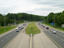
A series of projects saw the parkway completely rebuilt through its central section between the mid-1990s and early 2010s, including a concrete median barrier, additional lanes, and a new flyover ramp at Highway 8.
[5] At the Kitchener city limits at Trussler Road the concurrency of Highway 7/8 continues west as a four lane freeway towards Stratford.
It then crosses over the Canadian National Railways Huron Park spur, the adjacent ION LRT line, and Schneider Creek immediately west of an interchange with Regional Road 53 (Courtland Avenue).
Now serving as the boundary between the residential neighbourhoods of Rockway to the north and Vanier to the south, the route curves north-northeast to reach an interchange with the Freeport Diversion (also known as the King Street Bypass or Highway 8 expressway).
Due to the close proximately of these two interchanges, the Conestoga Parkway utilizes a brief local–express system for approximately 1.7 kilometres (1.1 mi).
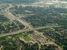
[2][3][6] Now passing through light industry in the Northward neighbourhood, the Conestoga Parkway makes a broad curve to the west to avoid the Grand River and meets Regional Road 29 (Lancaster Street), which features a partial interchange.
[2][3][6] The Conestoga Parkway enters into Waterloo with the suburban neighbourhood of Lincoln Heights to the west and greenfields and Betchel Park to the east.
After 1.5 kilometres (0.93 mi), it crosses Laurel Creek and encounters an interchange with Regional Road 57 (University Avenue) before curving gradually to the west-northwest.
An interchange with Regional Road 50 (Northfield Drive) also carries the ION LRT line over the route as it travels through an area of light industry.
[1][3] Although the concept of a ring road around Kitchener and Waterloo originated from the Kitchener-Waterloo and Suburban Planning Board in 1948,[9][10] actual consideration was not given to it until it was recommended by a 1961 traffic study.
Land was gradually purchased over the intervening years and picked up considerably when plans for the expressway system were first raised in late 1962.
A shortlist of 12 publicly-submitted names was prepared, and included Mackenzie King, John Patrick, Eby-Erb (early Mennonite settlers), Dan Detweiller (a founder of the Ontario hydroelectric system[25]), Frederick Banting, Centennial, Pioneer, Grand Valley, Golden Triangle, The Kingsway, and Conestoga.
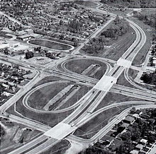
[33] This section, which was built along the alignment of Henry Strum Boulevard, was opened to traffic between Courtland Avenue and King Street on November 25, 1968.
[37] Construction of this section, through undeveloped farmland between Bridgeport Road and the southern interchange with King Street North, took place beginning in 1969.
[38] On the western leg, a section between Courtland Avenue and Fischer-Hallman Drive opened on September 1, 1971, completing the Kitchener–Waterloo Expressway project.
[21][39] By this time, construction was underway on a new two lane alignment of Highway 7/8, first announced in 1963, to connect the New Hamburg Diversion with the Conestoga Parkway at Fischer-Hallman Drive.
The extension, which featured an at-grade intersection with Northfield Road and a grade-separation with the northern King Street North, was opened in late August, 1977.
[48][49][50] Construction began to widen the route as far west as Waterloo Regional Road 12 (Queen Street), south of Petersburg, on July 6, 1992, with a planned completion by August 1993.
[58] In the early 1990s, the provincial government announced plans to widen the Conestoga Parkway and Freeport Diversion, as well as to improve the interchange between the two.
[63] Construction instead began in April 2002, which involved shifting one of the retaining walls further north and a new Franklin Street bridge to accommodate the eight lane cross-section freeway.
[65] Construction began in 2012 to widen the parkway to six lanes from east of Courtland Avenue to west of Fischer-Hallman Road, including the installation of a median barrier.
[69][70] The Victoria Street overpass was demolished overnight on February 23–24, 2018, and was replaced with a new structure that reopened to traffic on October 28; the new bridge is longer and has a higher elevation to accommodate the future ramps between Highway 7 and the Conestoga Parkway.