Congo Basin
[3] However, deforestation and degradation of the ecology by the impacts of climate change may increase stress on the forest ecosystem, in turn making the hydrology of the basin more variable.
[3] A 2012 study found that the variability in precipitation caused by climate change will negatively affect economic activity in the basin.
By the start of the Late Cretaceous, a connection with the Trans-Saharan seaway led to a significant marine incursion into the basin (evidence of an earlier, Late Jurassic marine intrusion is disputed), causing it to serve as a connection between the southern Atlantic Ocean and the Tethys Ocean.
Many of the formations deposited by these freshwater and marine habitats are rich in pollen, invertebrate, and vertebrate (primarily fish) fossils.
Kimberlite pipes that are thought to have formed during the Cretaceous, possibly due to a shock from a sudden decrease in the rate of seafloor spreading of the southern Mid-Atlantic Ridge, are the source of the region's famous diamonds.
[5] The following sedimentary geological formations have been deposited in the basin:[5] Congo is a traditional name for the equatorial Middle Africa that lies between the Gulf of Guinea and the African Great Lakes.
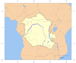
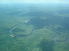
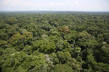
The basin is a total of 3.7 million square kilometers and is home to some of the largest undisturbed stands of tropical rainforest on the planet, in addition to large wetlands.
Countries wholly or partially in the Congo region:The first inhabitants of the Congo Basin area were believed to be pygmies, and at that time, the dense forests and wet climate kept the population of the region low, with the prevention of hunter-gatherer society, whose remnants of their culture survive to the present day.
The differences in temperature between the deserts and the Congo Basin is important for driving wind systems known as African easterly jets,[14] which affect climate and weather in the Sahel and Southern Africa.
Predictions for future unabated deforestation estimate that by 2050 activities in the DRC will release roughly the same amount of carbon dioxide as the United Kingdom has emitted over the last 60 years.
[18] In 2017, British scientists discovered that peatlands in the Cuvette Centrale, which cover a total of 145,500 sq km, contain 30 billion tonnes of carbon, or 20 years of U.S. fossil fuel emissions.
The World Bank agreed to provide $90 million of development aid to Democratic Republic of the Congo with the provision that the government did not issue any new concessions granting logging companies rights to exploit the forest.
[24] The government has written a new forestry code that requires companies to invest in local development and follow a sustainable, 25-year cycle of rotational logging.
When a company is granted a concession from the central government to log in Congo, it must sign an agreement with the local chiefs and hereditary land owners, who give permission for it to extract the trees in return for development packages.
L’Île Mbiye, an island in the Lualaba River in Kisangani, is part of a project about forest ecosystem conservation, conducted by Stellenbosch University.
The main Congolese environmental organization working to save the forests is an NGO called OCEAN, which serves as the link between international outfits like Greenpeace and local community groups in the concessions.