Connecticut River
[15] The Mattabesset (Tunxis) tribe takes its name from the place where its sachems ruled at the Connecticut River's Big Bend at Middletown, in a village sandwiched between the territories of the aggressive Pequots to the south and the more peaceable Mohegans to the north.
[17] The agricultural Pocomtuc tribe lived in unfortified villages alongside the Connecticut River north of the Enfield Falls on the fertile stretch of hills and meadows surrounding Springfield, Massachusetts.
[19] The Pocomtuc villagers at Agawam helped Puritan explorers settle this site and remained friendly with them for decades, unlike tribes farther north and south along the Connecticut River.
[20][21] The region stretching from Springfield north to the New Hampshire and Vermont state borders fostered many agricultural Pocomtuc and Nipmuc settlements, with its soil enhanced by sedimentary deposits.
[22] The Western Abenaki (Sokoki) tribe lived in the Green Mountains region of Vermont but wintered as far south as the Northfield, Massachusetts, area.
The first group of pioneers left the Plymouth Colony in 1632 and ultimately founded the village of Matianuck (which became Windsor, Connecticut) several miles north of the Dutch fort.
[29] Shortly after Hooker's arrival, Newtowne annexed Matianuck based on laws articulated in Connecticut's settlement charter, the Warwick Patent of 1631.
The treaty allowed the Dutch to maintain their trading post at Fort Huys de Hoop, which they did until the 1664 British takeover of New Netherland.
[31] The Fort at Number 4 in Charlestown, New Hampshire, was the northernmost British colonial presence on the Connecticut River until the end of the French and Indian War in 1763.
The Abenaki had resisted British colonial settlement for decades, but colonists began settling north of Brattleboro, Vermont, following the war.
[33] New York protested these grants, and King George III decided in 1764 that the border between the provinces should be the western bank of the Connecticut River.
[37] The Treaty of Paris (1783) that ended the American Revolutionary War created a new international border between New Hampshire and the Province of Canada at "northwesternmost headwaters of the Connecticut".
The broad, fertile Connecticut River Valley attracted agricultural settlers and colonial traders to Hartford, Springfield, and the surrounding region.
[39] The Connecticut River Valley functioned as America's hub of technical innovation into the 20th century, particularly the cities of Springfield and Hartford, and thus attracted numerous railroad lines.
[40] Starting about 1865,[41] the river was used for massive logging drives from Third Connecticut Lake to initially water powered sawmills near Enfield Falls.
Men guided logs through a 400-foot (120 m) drop along the length of Fifteen-Mile Falls[41] (now submerged under Moore and Comerford reservoirs), and through Logan's Rips at Fitzdale, Mulligan's Lower Pitch, and Seven Islands.
[41] In March 1936, due to a winter with heavy snowfall, an early spring thaw and torrential rains, the Connecticut River flooded, overflowing its banks, destroying numerous bridges and isolating hundreds of people who had to be rescued by boat.
Sandbagging by the National Guard and local volunteers helped prevent the dam's powerhouse from being overwhelmed, despite blocks of ice breaking through the upstream walls.
The city lost power, and nighttime looting caused the police to issue a "shoot on sight" edict; 800 National Guard troops were brought in to help maintain order.
The American Red Cross and local, state and federal agencies, including the WPA and the CCC, contributed aid and manpower to the effort.
When the water receded, it left behind silt-caused mud which in places was 3 feet (1 m) thick; the recovery effort in Springfield, at the height of the American Great Depression, took approximately a decade.
While the southern part of the valley in Massachusetts is heavily urbanized, the northern section is largely rural and the local agriculture is well known for Connecticut shade tobacco.
Two million residents live in the densely populated Hartford-Springfield region, which stretches roughly between the college towns of Amherst, Massachusetts, and Middletown, Connecticut.
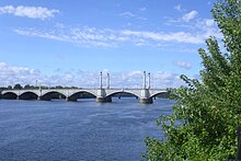
Hartford, the second-largest city and the only state capital on the river, is at the southern end of this region on an ancient floodplain that stretches to Middletown.
[7] Major tributaries include (from north to south) the Passumpsic, Ammonoosuc, White, Black, West, Ashuelot, Millers, Deerfield, Chicopee, Westfield, and Farmington rivers.
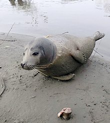
Harbor seals have been recorded traveling upriver as far north as Holyoke in pursuit of migratory fish; it is possible that they ranged farther upstream before the dam was built.
Freshwater sponges the size of dinner plates have been found by scuba divers at depths of more than 130 feet (40 m), thought to be the deepest location of the river, around the French King Bridge in Erving, Massachusetts.
Two tail-water dams provide cold river water for miles downstream, making for bountiful summer fishing on the Connecticut.
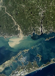
[75] In Massachusetts, the most active stretch of the Connecticut River is centered on the Oxbow, 14 miles (23 km) north of Springfield in the college town of Northampton.
Currently, a website provides water quality reports twice a week, indicating whether various portions of the river are safe for swimming, boating and fishing.