Norwalk Harbor
Typical freight included fuel oil, sand, gravel, stone, and shellfish (particularly oysters and lobsters).
There is also a 0.6-mile (0.97 km)-long, six-foot-deep channel, 125–150 feet (38–46 m) wide, extending northeast from the 10-foot (3.0 m) anchorage opposite Fitch Point to the head of the harbor at East Norwalk.
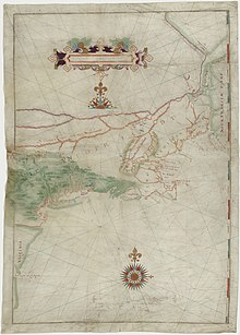
In 1614 Dutch navigator Adriaen Block explored the Connecticut coast aboard the Onrust and mapped the Norwalk Islands which lie at the outer boundary of the harbor.
[5] On January 21, 1897, the United States Congress agreed to spend $73,100.00 on aids to navigation in Norwalk Harbor including lights and fog signals.
[5] In October 1955 a great flood washed down the Norwalk River and destroyed many of the buildings adjacent to the riverbanks.
The salt marsh just south of the Yankee Doodle bridge on the river's west bank was turned into a garbage dump, but has since been closed, capped, and turned into "Oyster Shell Park" (not to be confused with the native Siwanoy shell middens across the river on the east bank near "Oyster bend").
[13] A utility project in the fall of 2007 replaced an electric power transmission line that runs from Connecticut to Long Island.
[14] The existing cables are joined at the oil-fired electric generating substation on Manresa Island in Norwalk Harbor.
[15] The Skyline Princess, a 120-foot (37 m) motor yacht out of New York, makes port of call stops at Veterans Park.
[16] The harbor is a "drowned river valley" flooded as the sea rose at the end of the last ice age.
The second (created during the Acadian mountain-building event of 485–440 million years ago) runs along a line north from Noroton Point on Sheffield Island Harbor toward Exit 15 on Interstate 95.