Contiguous United States
[1][2] The term excludes the only two non-contiguous states, which are Alaska and Hawaii (they are also the last two states to be admitted to the Union), and all other offshore insular areas, such as the U.S. territories of American Samoa, Guam, the Northern Mariana Islands, Puerto Rico, and the U.S. Virgin Islands.
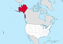
The related but distinct term continental United States includes Alaska, which is also on North America, but separated from the 48 states by British Columbia in Canada, but excludes Hawaii and all the insular areas in the Caribbean and the Pacific.
However, the total area of the United States, including Alaska and Hawaii, ranks third or fourth.
[citation needed] Residents of Alaska, Hawaii and off-shore U.S. territories have unique labels for the contiguous United States because of their own locations relative to them.
Alaska is the northwest extremity of the North American continent, separated from the U.S. West Coast by the Canadian province of British Columbia.
[23][24] Puerto Rico is an unincorporated territory of the United States located in the northeast Caribbean Sea, approximately 1,000 miles (1,609 km) southeast of Miami, Florida.
[25] The U.S. Virgin Islands is a U.S. territory located directly to the east of Puerto Rico in the Caribbean Sea.
[29] Apart from off-shore U.S. islands, a few continental portions of the contiguous United States are accessible by road only by traveling through Canada.