Cook Inlet
[2] The Cook Inlet and both its arms are bodies of brackish water, containing a turbid mix of ocean salt-water and freshwater runoff from the various rivers and streams.
The watershed includes the drainage areas of Denali (formerly named Mount McKinley) and is the collection point for the runoff from many surrounding glaciers, leading to the high turbidity and large silt deposits.
The valley left by this continental compaction remains open to the Gulf of Alaska to the south, forming the inlet as it exists today.
In 1964, a megathrust earthquake occurred when over 600 miles of the Aleutian fault ruptured, uplifting the Kenai Mountains 60 feet (20 meters) in under 5 minutes.
It devastated Anchorage where much of downtown dropped several stories, and the mountains surrounding the Turnagain Arm subsided 8 feet (2.4 meters), submerging the towns of Portage and Girdwood, as well as long stretches of the Seward Highway.
Hot magma and steam from the subducting ocean floor build up within these volcanoes, which tend to erupt in fairly regular cycles with very explosive force, often spewing volcanic ash tens of thousands of feet (several kilometers) high.
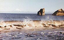
While lined with large areas of silt and mudflats, the central and upper inlet is filled with narrow troughs that may be 150 to 300 feet (50 to 100 meters) deep.
Large bores tend to occur after extreme tidal lows, appearing as a wall of water sometimes over 10 feet high as the tide comes in all at once.
[12] Unlike areas around the Bering Sea where weather is largely affected by sea ice, the waters of the inlet are warmed by the Alaska Current in the Gulf of Alaska, part of the North-Pacific Subpolar Gyre, which affects the climate and keeps the temperatures in the Cook Inlet region fairly moderate compared to the extremes found in other parts of the state.
The Lebedev Lastochkin Company leader Stepan Zaikov established a post at the mouth of the Kenai River, Fort Nikolaevskaia, in 1786.
Under orders by the British Crown to ignore any such rivers and inlets, he had initially planned to pass it by, but at the insistence of John Gore and many others of his crew, he reluctantly agreed to explore the area.
Cook anchored at Ship Creek and encountered the local Natives for the first time when two men approached in kayaks, invited them to come ashore.
[15] The SS Farallon was a wooden Alaskan Steamship Company liner that struck Black Reef in the Cook Inlet on January 5, 1910.
During the 1964 Alaska earthquake, areas around the head of Turnagain Arm near Girdwood and Portage dropped as much as 8 feet (2.4 m) by subsidence and subsequent tidal action.
These mudflats can also be dangerous to walk on, exhibiting quicksand-like characteristics, and have claimed the life of at least four people who have wandered out on them, usually tourists, with many more being rescued every year.
[23][24][25] Cruise ships dock at Seward on the Gulf of Alaska or Whittier in Prince William Sound and transport passengers via bus or train to Anchorage.
[29] In 2000, the US National Marine Fisheries Service listed the Cook Inlet beluga whale population as depleted and began development of a conservation plan.
The Coastal Marine Institute at the University of Alaska Fairbanks's School of Fisheries and Ocean Sciences working with the U.S. Department of the Interior's Minerals Management Service (MMS), began a three-year project in 2003 focusing on the water circulation in Cook Inlet.
[31] Cook Inletkeeper, a member of the Waterkeeper Alliance, began in 1994 when a group of Alaskans became concerned about the rapid ecological changes in the inlet.
The group formally incorporated the following year using settlement proceeds from a Clean Water Act lawsuit against Cook Inlet oil and gas producers.
[32] Their stated mission is to "protect Alaska's Cook Inlet watershed and the life it sustains," with a focus on clean water, healthy habitat, local economies, and energy.