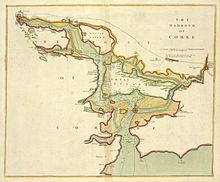
Cork Harbour
It is one of several which lay claim to the title of "second largest natural harbour in the world by navigational area" (after Port Jackson, Sydney).
Traditional heavy industries have waned since the late 20th century, with the likes of the closure of Irish Steel in Haulbowline and shipbuilding at Verolme.
Prior to the transfer of the treaty ports in 1938, Cork Harbour was an important base for the British Royal Navy.
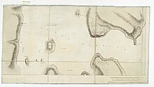
In the 18th century, fortifications were built on and opposite Haulbowline Island to protect the anchorage in Cobh - including Cove Fort (1743).
At the time of Irish independence, Cork Harbour was included, along with Berehaven and Lough Swilly, in a list of British naval establishments that would remain under the control of the Royal Navy, although the naval dockyard on Haulbowline Island was handed over to the Irish Free State in 1923.
Although the Royal Navy appreciated the location of Cork Harbour, particularly for submarines, which had a significantly shorter range in the 1920s, maintenance of the fortifications became an issue after Ireland became independent.
The political uncertainty over the future of the treaty ports meant that the British government was not inclined to invest in their upgrade.
Finally, if the Irish Free State was hostile during any conflict, the treaty ports would have to be supplied by sea rather than land, wasting resources.
As the shipping channels get shallower the farther inland one travels, access becomes constricted, and only vessels up to 60,000 DWT can sail above Cobh.
All vessels accessing the quays in Cork city must be piloted and all vessels exceeding 130 metres in length must be piloted once they pass within 2.5 nautical miles (4.6 km) of the harbour entrance at a point marked by the Spit Bank Lighthouse which is the landmark boundary for compulsory pilotage.
Tivoli (downstream of the older city quays) provides container handling, facilities for oil, livestock and ore and a roll on-roll off (Ro-Ro) ramp.
In addition to the ferry terminal, which provides a service to Roscoff in France, Ringaskiddy has a deep water port.
Historically, Cobh (under its former name Queenstown) was one of the principal ports through which flowed the stream of emigrants stemming from the Great Famine in the 1840s.
There are also a number of private berths around the harbour, with several centred on Whitegate, Passage West, Rushbrooke, Ringaskiddy and Haulbowline.
There is another marina on Great Island opposite East Ferry, while Monkstown and Blackrock are used for boating, canoeing, windsurfing and jet-skiing.