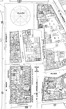
Los Angeles Street
Here, the Coronel Adobe blocked the path north one block to the Plaza, but just slightly to the right (east) of the path of Los Angeles Street was Calle de los Negros (Spanish-language name; marked on post-1847 maps as Negro Alley or Nigger Alley), a narrow, one-block north–south street likely named after darker-skinned Mexican afromestizo and/or mulatto residents during the Spanish colonial era.[8][9].
At the north end of Calle de los Negros stood the Del Valle adobe (also known as the Matthias or Matteo Sabichi house),[10][11] at the southern edge of which one could turn left and enter the plaza at its southeast corner.
[12][13] The neglected dirt alley was already associated with vice by the early 1850s, when a bordello and its owner both known as La Prietita (the dark-skinned lady) were active here.
Its other businesses included malodorous livery stables, a pawn shop, a saloon, a theater and a connected restaurant.
Historian James Miller Guinn wrote in 1896, "in the flush days of gold mining, from 1850 to 1856, it was the wickedest street on earth...In length it did not exceed 500 feet, but in wickedness, it was unlimited.
Here the ignoble red man, crazed with aguardiente, fought his battles, the swarthy Sonorian plied his stealthy dagger, and the click of the revolver mingled with the clink of gold at the gaming table when some chivalric American felt that his word of “honah” had been impugned.
There, William Estrada notes, the "Chinese of Los Angeles came to fill an important sector of the economy as entrepreneurs.
Some became proprietors and employees of small hand laundries and restaurants; some were farmers and wholesale produce peddlers; others ran gambling establishments; and some occupied other areas left vacant by the absence of workers in the gold rush migration to California."
[3][14] The site of Calle de los Negros is now the Pueblo parking lot and a cloverleaf-style entrance to the US 101 freeway.
Around 1849, they sold the house to a "sporting fraternity", which operated a popular 24-hour gambling establishment with games including monte, faro, and poker; up to $200,000 in gold could be seen on the tables at a time.
After that, still in the 1850s, it became a grocery and dry goods store (Corbett & Barker), then a storage house for iron and hard lumber for Harris Newmark Co.