Ridge Route
The first piece of Ridge Route Road out of Castaic was realigned as recently as the late 1990s when the North Lake housing development was built.
A popular place, composed of white clapboard buildings, it was described in a 1932 highway beautification pamphlet as "the sort of filling station that gets into a national forest and is no addition thereto".
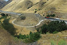
[17] About two miles (3.2 km) north of the National Forest Inn is Serpentine Drive, where the road curves around the sides of hills as it climbs out of a low point in the route (about 3,200 feet (980 m) above sea level).
The Reservoir Summit Café was a popular high-class restaurant on the east side of the road, closed in the late 1920s; the foundation remains.
[20] Kelly's Half Way Inn was roughly halfway between Los Angeles and Bakersfield, on a small knoll with a single tree on the east side of the road; all that remains is remnants of the foundation.
[21] The Tumble Inn, later Mountain View Lodge, was on the west side of the road, and closed when the Ridge Route Alternate opened in 1933.
The place, which had become a ceramics factory, burned down on April 29, 1961, from a fire started by the new owner—who was converting it into a "camp-type operation" for underprivileged children—burning trash in the fireplace.
[15] The Ridge Route crosses the West Branch California Aqueduct with SR 138, splitting to the northwest on Gorman Post Road.
The original plan was to build the road nearer to the center of the canyon, but a March 1914 flood destroyed the work, and the grading was redone higher up.
In order to keep the stages from running directly northwest from San Bernardino and bypassing Los Angeles, the Los Angeles County Board of Supervisors spent $8000 in 1858 (about $219,318 in 2023)[27] to deepen the cut—later Beale's Cut—at San Fernando Pass, south of Saugus and Newhall (east of Sierra Highway, west of the Antelope Valley Freeway or State Route 14).
[29] The railroad's route between Saugus and Bakersfield was even longer than that of El Camino Viejo and the Butterfield Overland Stage, heading east through Soledad Canyon before turning north via Palmdale to Mojave and northwest over Tehachapi Pass.
[33] These routes all shared the roadway south of Saugus, which was generally flat but included the crossing of San Fernando Pass.
[34] To improve the crossing, the county bypassed the cut with the narrow 435-foot (133 m) Newhall Tunnel, for railroad traffic only, which opened in October 1910.
Due to cost and drainage concerns, and a desire to reduce altering the terrain, the road was built with 697 curves, high in the mountains.
[36][37] Construction on the Ridge Route, officially considered to run from Castaic Junction (west of Saugus on the road to Ventura) to the bottom of the grade at Grapevine,[5] began in 1914.
[44] The continuation south via Saugus and the Newhall Tunnel towards Los Angeles, also part of Route 4, was added to the state highway system in 1917.
[35] The San Francisco Chronicle called the new route "one of the most remarkable engineering feats accomplished by the State Highway Commission.
[46] Work on paving the Ridge Route with 4-inch (100 mm) thick reinforced concrete[47] began in 1917, but was delayed until 1919 by the U.S. entry into World War I.
[48] Asphalt was added on top of the concrete for 20 miles (32 km) south from Swede's Cut in 1922, and in 1924 a number of blind curves were widened and straightened.
A new bypass of the Newhall Tunnel, through Weldon Canyon, had opened on May 28, 1930, giving drivers a better route all the way from Los Angeles to Bakersfield.
[53] Even this four-lane Ridge Route Alternate was not adequate for the traffic, and the first section of eight-lane freeway I-5 with a minimum curve radius of 3,000 feet (910 m) opened in 1960 in Grapevine.
Large parts of the Ridge Route Alternate were incorporated into the new roadway, but the area through the present Pyramid Lake was completely bypassed.
The longest preserved segment was the part bypassed by the Ridge Route Alternate, between Castaic and SR 138 near Sandberg, including the portion through the Angeles National Forest.
[57] The route was repaired in 2005 following heavy rainfall, but the road was not reopened as of early 2013[update], due to objections from Angeles National Forest officials.