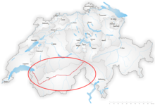
Correction of the Rhône upstream of Lake Geneva
In September 2000, the Valais Grand Council decided to undertake the third correction of the Rhône from Gletsch to Lake Geneva, in collaboration with the Canton of Vaud.
[3] The Rhône's main tributaries upstream of Lake Geneva are the Massa, fed by the Aletsch glacier, the Lonza in the Lötschental valley, and the Grande Eau, which rises in the Diablerets massif.
Far from the stereotype of a marshy, unusable valley floor, far from the cliché of a frightening river to be avoided, their existence was punctuated by agro-pastoral practices that perfectly integrated the varied resources of the Rhône plain.
In fact, according to Théodore Kuonen, "the practice of grazing livestock dates back to the time of the first settlers, which is attributed to the Neolithic period.
Nevertheless, the construction of large Roman villas on the plain suggests the existence of barriers (from the Latin words barra or barreria) as early as Antiquity.
In the 14th century, the Count of Savoy maintained the section of the Great St. Bernard route around the Saint-Maurice d'Agaune toll station, some 20 km from Bex to Martigny.
The land thus represents a major economic stake, prompting riverside communities to fight over it and restrict the river's freedom to extend meadows and crops.
[11] In the Valais, episodes of violent rainfall caused numerous floods and a significant increase in the amount of material that the Rhône struggled to transport.
As early as the 15th century, the river's inhabitants realized that the Rhône had to be straightened to increase the force of the current, to protect bridges, roads, and access paths to farmland, and to guarantee the boundaries of communes and properties.
[8] In 1756, Bern and Valais decided "to draw up an exact plan of the Rhône in its present state, with all the barriers and the old and new limits", to put an end to the incessant conflicts caused by the delimitation of the riverbed.
Devastating floods in 1545, caused by heavy rains, were reported at the Diet of February 26, 1546: "This session, decided on at the last Christmas Council, is being held today in connection with the terrible flooding of the Rhône, as a result of which the route du Pays downstream from the Morge, the property owned and leased, the routes, the common pastures, and other places still, could be entirely lost, wiped out by the waters, if appropriate and indispensable measures are not taken, and if the Rhône is not led in a straight line."
[14] As early as 1803, the Valais State Council convened the communes of Riddes, Saxon, Martigny, Fully, Saillon, and Leytron to decide on a joint plan to give the river a specific course.
What's more, since the Rhône did not become part of the public domain of the State of Valais until 1933, all costs had to be borne by the owners of the river, whether private individuals, communes, or bourgeoisies.
[17] The extensive damage caused by the flood of 1860 prompted the Valais State Council to ask the Swiss Confederation for help in damming the Rhone.
However, having had to pay off substantial war debts following the occupation of Valais after the defeat of the Sonderbund, the canton lacked the resources to undertake the damming of the river.
[19] This means that most of the costs will be borne by the riverside communities themselves, as the canton will only pay for the dikes directly protecting the main road and the bridges it crosses.
As citizens are often unable to pay the full cost of taxes, men, women, and children work on the Rhône correction during "corvées" (see illustration by Raphaël Ritz).
The riverbed was heightened by the movement of tributaries and the inability of the infrastructure in place to ensure sufficient current velocity to carry away gravel and other sediments.
Anxiety is particularly high in the central Valais, where rising water levels are proving to be the most significant, even though the region has the highest population density and the most prosperous and extensive cultivated areas.
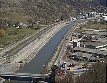
The second Rhône correction, in 1936, consisted of reinforcing the dikes and raising them, as well as narrowing the bed to increase its carrying capacity by linking the heads of the groins with riprap.
Finally, as the gravel pits have removed a great deal of material in recent decades, the bottom of the Rhône has fallen (red part in the illustration) and is now much lower than it was at the end of the second correction.
Hydrological studies[25] indicate that the 100-year flood (occurring on average once every hundred years) has a discharge of 1,260 m³/s at Branson (Fully) and 1,660 m³/s³ at the Porte du Scex, near Lake Geneva.
The current layout of the Rhône is no longer able to protect the plain against the 100-year flood defined above, due to the poor condition of the dykes and the inadequate size of the riverbed.
[28] Today, they are dangerous due to their lack of stability (risk of internal erosion and hydraulic foxing), as well as deterioration caused by tree roots and burrowing animals.
As a result, more than 11,000 hectares of land are currently threatened by flooding in the Rhône plain in Valais, and the cumulative potential damage exceeds ten billion Swiss francs.
[29] The hazard management principles applied in the 3rd Rhone Correction are based on the lessons learned from the major floods of the late 20th century in Switzerland and are defined in federal[30][31] and cantonal legislation.
These include reorganizing the territory by replacing expropriations with parcel exchanges and consolidations, as well as providing opportunities to adapt infrastructure (irrigation, drainage, roads) and improve production conditions.
It was presented to the Grand Council of Valais, which adopted it in September 2000 and requested an extension of the third correction (initially planned from Brig to Martigny) from Gletsch to Lake Geneva, in collaboration with the Canton of Vaud for the inter-cantonal section.
These alternatives focused on deepening the river and claimed to offer equivalent safety at a third of the cost, timeframe, and footprint of the proposed project.
[55][56] Defending the principle, rejected by expert assessments,[49][50][51] of prioritizing deepening the river, members of the Swiss People's Party (UDC), joined by representatives of the agricultural sector, launched a referendum against the decree, which had been approved by 98 votes to 24, with 2 abstentions,[56] in the Grand Council.