Corvo Island
The documented history of the Azores originates with non-official exploration during the period of the late 13th century, resulting in maps, such as the Genovese Atlas Medici from 1351, which mentions obscure islands in an undefined Atlantic archipelago.
The navigator Diogo de Teive discovered both islands of the Azores' Western Group on his 1452 return from the Banks of Newfoundland following his second voyage of exploration.
The Portuguese royal chronicles state that when Teive arrived, he found a statue of a man on horseback, standing on a plinth bearing an inscription in an alphabet they did not understand.
Within the caldera are several cinder and spatter cones (20–30 m (65–100 ft) in height) giving rise to small lakes, peat bogs, and islets (two long and five rounded).
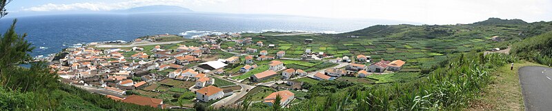
Remnants of the ancient volcano are partially preserved in the southern and eastern flanks of the island (which retain altitudes between 500 and 700 m (1,600 and 2,300 ft) above sea level).
At the end of October 2012, following several days of excess rainfall, a landslide occurred that dislodged geological debris along the northwestern corner of the island, resulting in the formation of small islets, that progressively transformed into a peninsula and, finally a fajã.
It includes principally two categories, and associated areas of intervention: The islands of Corvo and neighbouring Flores, along with the surrounding waters, form the 210,400 ha Corvo and Flores Important Bird Area (IBA), designated as such by BirdLife International because it provides feeding and breeding sites for populations of Cory's, little and Manx shearwaters, as well as roseate and common terns, and, possibly, Madeiran storm petrels.
Portinho da Areia, on the extreme west of the southern coast (at the end of the airport's runway) is the only beach and principal swimming area on the island.
It currently occupies 17.5% of the area of the municipality, and concentrated on small parcels in the eastern half of the island and along the northern parts of Vila do Corvo.
In this patchwork of volcanic hedge-rows, farmers concentrate on semi-permanent crops (potatoes, some cereals, including wheat and citrus orchards).
These flights have since been operated by alternating[clarification needed] DeHavilland Dash 8 aircraft, as part of the fleet revitalization program of the late 20th century.