Queen Maud Land
On 23 June 1961, Queen Maud Land became part of the Antarctic Treaty System, making it a demilitarised zone.
There is no permanent population, although there are 12 active research stations housing a maximum of around 40 scientists, the numbers fluctuating depending on the season.
[9] The territory is estimated to cover around 2,700,000 square kilometres (1,000,000 sq mi),[5] which roughly corresponds to the sizes of India,[10] Argentina[11] or Kazakhstan.
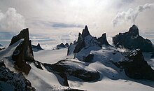
[3] Geologically, the ground of Queen Maud Land is dominated by Precambrian gneiss, formed c. 1 to 1.2 Ga, before the creation of the supercontinent Gondwana.
The mountains consist mostly of crystalline and granitic rocks, formed c. 500 to 600 Ma in the Pan-African orogeny during the assembly of Gondwana.
[3] Early Norwegian research activities in Antarctica rested entirely on whaling and sealing expeditions funded by ship owners, particularly by Christen Christensen and his son Lars.
[17] Norway's claim was disputed by Germany,[26] which dispatched the German Antarctic Expedition in 1938, led by Alfred Ritscher, to fly over as much of it as possible.
[26][note 4] On 14 January 1939, five days prior to the German arrival, Queen Maud Land was annexed by Norway,[18] by royal decree:[17] That part of the mainland coast in the Antarctic extending from the limits of the Falkland Islands Dependencies in the west (the boundary of Coats Land) to the limits of the Australian Antarctic Territory in the east (45° east long.
[18][30] Scientific operations were also a basis, with Norwegian contributions to international polar science extending back to the late 19th century.
The expedition established its winter quarters at a base called Maudheim at 71°S, 11°W, and mapped much of western Queen Maud Land.
[35][36] During the International Geophysical Year (1957–1958), year-round stations were established in Queen Maud Land by Norway, the Soviet Union, Belgium and Japan.
He personally named three mountains around the Troll station where he was based, although he chose to sleep outdoors in a tent, rather than in a bed inside.
[46] But there is a question on the actual boundaries of the claim, since the initial Norwegian demarcations both towards the South Pole and into the sea were left unclear.
[47] In 2015, Norway partially rectified this question by formally laying its claim to the area between the Queen Maud Land and the South Pole.
[7] Norwegian administration of Queen Maud Land is controlled by the Polar Affairs Department of the Ministry of Justice and the Police, located in Oslo.
[48] The annexation of the territory is regulated by the Dependency Act of 24 March 1933; Queen Maud Land was added on 21 June 1957.
Those who visit Queen Maud Land must follow laws regarding protection of nature, treatment of waste, pollution and insurance for search and rescue operations.
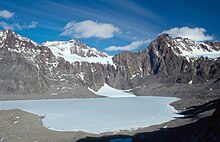
The Antarctic petrel lives on the sea ice for most of the year, with the exception of its breeding season (in Antarctica, from November to February), when it moves to the inland mountains and nunataks.
[51] The 3.9-square-kilometre (1.5 sq mi) area of ice-free cliffs in Princess Astrid Coast called Svarthamaren Mountain hosts Antarctica's largest known inland colony of breeding seabirds, almost 1 million (250,000 pairs) Antarctic petrels.
Snow petrels are generally spread out in smaller colonies throughout the mountainous areas of Queen Maud Land.
During the breeding season, the south polar skua feeds exclusively upon the eggs, as well as both young and adult birds, of both petrel species.
The Norwegian Polar Institute has not registered the occurrence of any threatened or rare plants or animals in Queen Maud Land, the known ones thus existing in healthy populations.
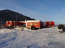
These are the Norwegian Troll and Tor; the German Neumayer Station III and Kohnen; and the Japanese Showa and Dome Fuji.
The remaining stations are seasonal, and include: the Belgian Princess Elisabeth Antarctica base; the Finnish Aboa; the Pakistani Jinnah; and the Swedish Wasa.
[2] It conducts geophysical, meteorological and seismological research, as well as air chemistry measurements and atmospheric ozone monitoring.
[62] Maitri's research focus on geology, and the study of the supercontinent Gondwana, when India and Antarctica belonged to the same landmass.
[65] Belgium's Princess Elisabeth Antarctica base was established as a project to promote polar sciences, as well as to demonstrate the possibility of building a zero emission station.
[67] Queen Maud Land is featured in the 2021 video game Battlefield 2042 as the setting of the multiplayer map Breakaway.