Coventry ring road
As one of the few British cities to see its ring road project pushed to completion, Coventry has received considerable attention as a source of research for post-war architecture.
[8] Junction 5 provides access to the south-eastern part of the city centre, via the B4544 New Union Street, and also links to a pair of roads heading south towards the suburb of Cheylesmore.
[13][15][16] In the early 20th century, Coventry was the fastest-growing city in the UK as people relocated from across the country to work in the expanding automotive, bicycle, aviation and armament industries.
A protégé of Patrick Abercrombie at the University of Liverpool School of Architecture,[19] Gibson assembled a team of young architects, with whom he produced plans more radical than Ford's.
Shortly after the first bombing, they met Lord Reith,[23] the government minister responsible for rebuilding, who advised them to plan the reconstruction "boldly and comprehensively" even if this meant high costs.
The council started work on the project in 1946, laying a commemorative stone on the future site of the shopping precinct and beginning the conversion of Broadgate, the city's historic hub, into a green central square.
In his 1945 "Coventry of the Future" plan, Gibson moved the proposed route of the ring road to the north and west of the 1941 version, with the new alignment centred on Broadgate.
[33] This retained many of Gibson's early ideas including a dual-carriageway layout, lanes for cyclists and pedestrians on both sides, and at-grade roundabout junctions connecting to all of the major radial routes out of the city.
Funding was limited following the economic hardship of the war,[35] and the council's priority was the rebuilding of bomb-damaged areas in the city centre and completing the precinct, to enable businesses and shops to resume full operation.
[37] The ring-road plan remained active and planners ensured that no new structures were situated close to the proposed route, to maintain its availability for road development.
The government had reduced investment expenditure significantly from late 1955, and in 1956 the Ministry of Transport and Civil Aviation (MOT) denied the council permission to build the entire road, indicating that only the south-eastern portion was likely to be approved at that time.
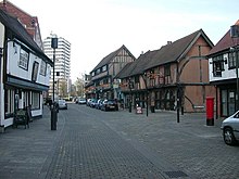
[52] Some features of the demolished areas were retained in the new road, for example stone setts from St John's Street, which were relaid as the divide between the cycle tracks and pavements.
The new road began at Hill Cross and ran roughly along the line of King Street to Swanswell Terrace, a total distance of 480 yards (440 m).
[64] A team of archaeologists led by Charmian Woodfield worked on the site for the next year, discovering a medieval cesspit containing 15th century pottery and a trench outside the wall which was built for additional protection.
To facilitate the construction of the roundabout, the council issued compulsory purchase orders on buildings owned by various shops and businesses close to the site.
But the Road Research Laboratory, at the time a UK government agency, had produced a formula for safe traffic weaving distances between such junctions.
But in December 1963 the City Engineer, Granville Berry, ended Yeomans' contract, citing a lack of progress, poor workmanship and the company's financial health as reasons.
But with the Butts radial road not yet complete the council decided to defer this, citing potential driver confusion at the southern end if complex temporary measures were put in place.
[106] The Hill Cross flyover and Holyhead Road underpasses were both opened on 18 July 1966, three months ahead of schedule, with construction workers removing the barriers and allowing traffic to flow.
[113] Demolition and clearing of the route was underway by late 1967,[114] and a £3.2 million MOT grant (equivalent to £73,400,000 in 2023) was approved, despite a government freeze on public spending at the time.
[125] It had initially been proposed in the early 1960s that the work in the area would include widening the A429 Warwick Road, but there was local opposition citing the loss of 47 mature trees and the plan was abandoned.
In his speech, he congratulated officials from the council who had overseen the project since its inception, but also lamented the "frustration and delay" which had lengthened the work from its original six-year timetable.
[144] Two days after the development was officially opened, the ring road was temporarily closed underneath the new deck, hosting a racing circuit as part of the Coventry MotoFest.
[143][145] In 2021, the UK government mandated the city council to improve Coventry's air quality as part of efforts to reduce nitrogen dioxide (NO2) levels.
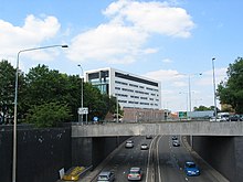
The designers chose a viaduct structure rather than an embankment at these junctions and positioned the abutments some distance from the roundabouts and slip roads, to maximise visibility.
Several of the car parks are situated directly underneath the elevated sections of the road itself, including under the long stretch in the east built during stage five and, until the 2020s junction 7 rebuild, inside the roundabout under the Moat Street flyover.
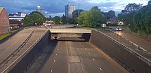
[167] A 2006 survey by the Coventry Telegraph found that many city residents regarded the subways as unsafe, and took lengthy detours or crossed the ring road directly to avoid using them.
included Coventry on its list, citing these driver difficulties, along with the view that the road creates a physical barrier isolating the city centre from its suburbs.
[170] In 2015, a group of nine writers and nine film-makers, led by Coventry artist Adam Steiner, created a series of poetry films about the ring road.
[174][175] In interviews with the BBC and the Guardian, Steiner commented that "it is the duty of artists and citizens to engage with issues of public space, control of architecture and the human experience of our built environment" and cited the ring road as having a "great presence, not dissimilar to the old city walls".