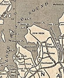
Cow Neck Peninsula
The Cow Neck Peninsula was named Cow Neck in the 17th century, in large part due to the fact that it served as a common pasture at the time.
[2][3][4][5] It is believed that 90% of the concrete that built the foundations of New York City came from the Port Washington sand mines, and that over 100 million tons of sand were shipped to Manhattan.
[7] On its west side, the Cow Neck Peninsula is bordered by Manhasset Bay.
[8] Some places on the Cow Neck Peninsula – notably in Flower Hill and Manhasset – reach elevations high enough for the skyline of New York City to be seen from ground level.
[9] The following towns are located on the Cow Neck Peninsula – either in part or in whole:[2][10] The Cow Neck Peninsula is located entirely within the Town of North Hempstead.