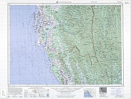
Cox's Bazar
Cox's Bazar (/ˌkɒksɪz bəˈzɑː/; Bengali: কক্সবাজার, romanized: Kôksbājār; pronounced [kɔksbadʒaɾ]) is a city, fishing port, tourism centre, and district headquarters in south-eastern Bangladesh.
[1][2] Located 150 km (93 mi) south of the city of Chittagong, Cox's Bazar is also known by the name Panowa, which translates literally as "yellow flower."
During the early 9th century, the greater Chittagong area, including Cox's Bazar, was under the rule of Arakan kings until its conquest by the Mughals in 1666.
[9] When the Mughal Prince Shah Shuja was passing through the hilly terrain of the present-day Cox's Bazar on his way to Arakan, he was attracted to its scenic and captivating beauty.
Captain Advocate Fazlul Karim, the first post-independence chairman of Cox's Bazar Municipality, established the Tamarisk Forest along the beach.
[9] In 1961 the Geological Survey of Pakistan initiated investigation of radioactive minerals like monazite around the Cox's Bazar sea-beach area.
This and the nearby airstrip of the Pakistan Air Force were the scene of intense shelling by the Indian Navy during the Bangladesh Liberation War.
During the war, Pakistani soldiers killed many people in the town, including eminent lawyer Jnanendralal Chowdhury.
The killing of two freedom fighters named Farhad and Subhash at Badar Mokam is also recorded in history.
[13] In September 2012 the municipality was the site of the Cox's Bazar and Ramu riots, where local Muslims attacked the Buddhist community over an alleged Quran desecration posted to Facebook.
This initiative includes building 40 new cyclone shelters, a relief administration and distribution center, and other facilities to bolster disaster resilience and support local populations.
[1] Cox's Bazar is located 150 km (93 mi) south of the divisional headquarter city of Chittagong.
Cox's Bazar town has an area of 6.85 km2 (2.64 sq mi), and is bounded by Bakkhali River on the north and East, Bay of Bengal in the West, and Jhilwanj Union in the south.
Most of the city is built on a floodplain that is lower in elevation than the dunes, making it more susceptible to flooding due to cyclones and storm surges.
The Cox's Bazar coastal plain was formed after the sea reached its present level around 6,500 years ago, with the area of the current floodplain originally forming a sediment sink that has since been gradually filled in by the Bakkhali river as well as smaller streams coming down from the hills.
[21] The climate of Cox's Bazar is mostly similar to the rest of the country, but with an even wetter southwest monsoon season due to its coastal location.
Cox's Bazar had a literacy rate (age 7 and over) of 55.72%, compared to the national average of 51.8%, and a sex ratio of 776 females per 1000 males.
A number of hotels, guest houses, and motels have been built in the city and coastal region, and many people are involved in the service industry.
[citation needed] People are involved in fishing and collecting seafood and sea products for their livelihood.
[citation needed] Besides a mix of small-scale agriculture, marine and inland fishing and salt production are other industrial sources that play important roles in the national economy.
In January 2024, two open top buses for tourists were launched, travelling from Laboni Point to Sabrang in Teknaf via Marine Drive.
Attractions also include parasailing, water biking, beach biking, horse riding, Cox Carnival circus show, Daria Nagar Ecopark, Cox's Bazar Development Authority, numerous architectural attractions, Shishu Parks and numerous photogenic sites.