Cox's Road and Early Deviations - Sodwalls, Fish River Descent Precinct
[1] The road from Emu Ford to Bathurst, a distance of 163.3 kilometres (101.5 mi) was completed in only six months during 1814 and 1815 by a working party composed mostly of convicts.
Governor Lachlan Macquarie decided to have a carriage road constructed across the Blue Mountains, to the country which had been "newly discovered" by Europeans in 1813.
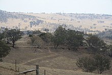
[1] The Cox's Road Fish River Descent Precinct is situated about 8 kilometres (5.0 mi) south of Sodwalls.
Cox selected a line towards the Fish River around 18 December 1814 after having previously ridden over the country west of Mount Blaxland.
His Journal records:[2][1] Sunday, 18 December: At 1⁄2 past 7 went forward on horseback to examine the road from hence to the Fish River.
On 25 December (Christmas Day) he "went forward to the Fish River and removed our caravan and one cartload there, where I pitched my tent leaving behind 3 bridges to make and five miles of road."
Cox described the Fish River bridge as follows:[3][1] 'It is strong and well built; on each end is a pier of 25 feet long which is well filled up with stone and a very little earth over it.
In April 1817 botanist Allan Cunningham described the journey over the Clarence Hilly Range to the Fish River as "severe and oppressive to our horses, the whole being sharp lofty hills and narrow boggy valleys, alternately", but he also reported that alterations were being made to improve the gradient.
[1] Cunningham's Journal for 3 August 1817 described this section as follows:[4][1] 'The journey over Clarence's Hilly Range, which is notorious for its difficulties when passing with loaded carts is at this period being made more easy for man and beast.
The surviving physical evidence shows relatively few locations where the extant road conforms with the dimensions specified in the instructions.
Again the most obvious and substantial physical evidence in this area relates to much later 1820s lines and improvements, including long sections of walling which support an embanked road formation winding down the hillsides.
From the "Ambervale" gate it appears to be less well used and in more original condition becoming a deeply eroded trench lined by trees left standing along the route to the river.
There are no equivalent improvements on the western side of the river, and this may be explained by the fact that from 1827 onwards it was becoming evident that efforts would be made to find and build a completely new line of road to Bathurst.
Cox described the bridge as "a strong and well-built one" but also noted that "floods will go over it" and no trace of what must have been an impressive structure survives today.
The successful construction of the road was symbolic of the conquest of the natural barrier created by the Blue Mountains, and represented Governor Macquarie's vision for the ongoing development of the colony beyond Sydney and its immediate surrounds.
Cox's Road enabled the later opening of the hinterland beyond the Blue Mountains for subsequent settlement, pastoral and agricultural expansion, which then escalated the dispossession of Aboriginal peoples from their lands.
[1] Cox's Road and Early Deviations - Sodwalls, Fish River Descent Precinct was listed on the New South Wales State Heritage Register on 25 March 2015 having satisfied the following criteria.
The 1814 road is tangible evidence of the development of the colony at Sydney and of the expansion of white settlement into western NSW.
The road symbolises the occupation of the country and Governor Macquarie's aspirations for the eventual opening of the interior to European settlement after the discovery of the Western plains by G. W. Evans in 1814.
In this respect the 1814-1815 Cox's Road has considerable symbolic significance as an official public work which laid the foundations for future development.
The crossing of the Blue Mountains, the surveying of a route to Bathurst and the building of Cox's Road were significant events in the period of Macquarie's governorship.
[1] William Cox's achievement using a small group of convict men in a short period of time and with no loss of life caused by road-making or other substantial difficulties, was reflective of his reputation as a more humane employer and magistrate than many of his contemporaries.
The leadership qualities, vision and skill he showed constructing the road would also be evident in later government contracts won by Cox for other public works.
[1] The place is important in demonstrating aesthetic characteristics and/or a high degree of creative or technical achievement in New South Wales.
[1] This Wikipedia article was originally based on Cox's Road and Early Deviations - Sodwalls, Fish River Descent Precinct, entry number 01958 in the New South Wales State Heritage Register published by the State of New South Wales (Department of Planning and Environment) 2018 under CC-BY 4.0 licence, accessed on 2 June 2018.