Creston, British Columbia
Forming a natural boundary, the lake and the Kootenay Pass on the Salmo–Creston highway divide the Pacific Time Zone from the mountain one.
When daylight saving ends, the time change migrates from Yahk to the Kootenay Bay ferry landing.
Defining Creston's place as being within either the East or West Kootenays can be contentious, as some locals regard it as being in a transition space between them.
Minor sports groups and teams, such as in hockey and baseball, belonged to East Kootenay leagues.
[2] Members would paddle their canoes across the flooded flats to harvest wild rice, one of the staples of their diet.
[4] Established in 1865, the section of the Dewdney Trail travelled southeast via present-day Wynndel and Creston, before following the Goat River valley northeastward.
[5] On an 1882 hunting trip, William A. Baillie-Grohman and Teddy Roosevelt camped in the vicinity of today's Creston.
The Columbia and Kootenay Steam Navigation Company's twice-weekly sailings between Nelson and Bonners Ferry served the growing community on the edge of the flats.
Sirdar was the rank assigned to the commander-in-chief of the British-controlled Egyptian Army in the late 19th to early 20th centuries.
Fred Little selected the name after Creston, Iowa, where he had worked for the Chicago, Burlington and Quincy Railroad, which also stood at the outlet of a major water body.
[21] In December 1914, the final twice weekly mixed train ran north to Creston,[22][23] and the Wynndel–Porthill track was lifted in 1916.
By 1900, a settlement was growing around Long's Creston and John Munroe's Queen's hotels on the portion of Little's subdivision below the tracks.
To meet demand, Little further subdivided above the tracks, to where William Crawford and Charles Faas moved their general stores, now the downtown.
[31] About 1884, likely associated with the Baillie-Grohman reclamation plan, the first settlers arrived, cleared the slopes around today's Creston, and planted orchards, but obtained no preemptions.
In partnership with the Kootenay Valley Power and Development Co., settlers completed reconstruction that year, reclaiming 3,100 ha (7,700 acres).
Later deterioration of the dykes resumed annual flooding, leaving the land suitable only for hay harvests.
As returning World War I veterans developed farms on the flat lands to the south, grain harvests increased.
In 2017, the pilot of a small plane safely made an emergency landing on Highway 3 west of Creston.
[38] The summer bus service between Kaslo and Calgary, instituted by a regional operator in 2019, included a Creston stop.
[41] In 1907, the Creston Power Light & Telephone Co (CPL&T) installed phone wires northwest to Duck Creek, east to Erickson, and south to Porthill, Idaho.
[27] The excess from electricity generation by the sawmill was sold to the Creston Power, Light and Telephone Company.
In 1934, West Kootenay Power & Light (WKP&L) replaced the mill supply, using transmission lines from the Goat River Dam.
[55] Creston offers an infrastructure typical of a town of this size, including brewery tours, a shopping mall, golf course and a large selection of motels, hotels, and three campsites.
Daily maximum temperatures are usually above freezing even in January except when air masses of Arctic origin move over the area.
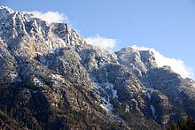
The sun-loving ponderosa pine forms a larger proportion of the vegetation near Creston's southern boundary.
White birch and trembling aspen grow to medium size; smaller trees include the Rocky Mountain maple and bitter cherry.
Large mammals at Creston include cougar, bear, beaver, coyote, deer, elk, moose, muskrat and river otter.
[78] The Creston area hosts British Columbia's only remaining population of northern leopard frog.
The floodplain soils are dark and poorly drained for the most part; they are excellent for pasture and grains where drainage is improved.
Some of the bench-land soils are brown and of good tilth; others are gray, deficient in organic matter, and have rather heavy calcareous subsoils.