Croatia–Serbia border dispute
[3] The cadastre-based boundary also traces the former riverbed of the Danube, which was changed by meandering and hydraulic engineering works in the 19th century, after the cadastre was established.
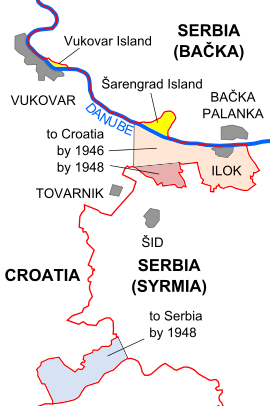
Further disputed areas are located near the town of Bačka Palanka,[5] and in the municipality of Sombor, at the tripoint of Croatia, Hungary and Serbia.
Prior to the ruling, Serbia asserted that the borders were subject to change following the breakup of Yugoslavia and the independence of Croatia.
[11] Four elderly individuals and four children were released immediately, while the rest were interviewed at a Yugoslav military barracks for two hours before being set free.
[16] After years of inactivity the inter-governmental commission established to identify and determine the border between Croatia and Serbia met in Zagreb in April 2010, only to conclude that there was a difference of opinions on the matter.
[20] In 2012, Josipović stated that Croatia should not block Serbia's EU accession over the issue and suggested that the dispute should be resolved through arbitration,[21] which is considered to be an acceptable solution by both countries.
On 13 April 2015, Vít Jedlička from the Czech Party of Free Citizens proclaimed the micronation Liberland on Gornja Siga, which was one of the pockets of land left unclaimed by both Croatia and Serbia.
[29] In 2019, pocket 3 on the western side of the Danube was also proclaimed by Australian politician Daniel Jackson as a micronation, the Free Republic of Verdis.
[30][31] The evolution of the Croatia–Serbia border began in 1699 with the Treaty of Karlowitz, transferring Slavonia and a portion of Syrmia from the Ottoman Empire to the Habsburg monarchy at the conclusion of the Great Turkish War.
The transferred territories were organised within the monarchy into the Kingdom of Slavonia, with its eastern border established at the Danube, and the defensive belt of Military Frontier stretching along the Sava River, governed directly from Vienna.
A year later Serbian Vojvodina was abolished and replaced by the crown land of the Voivodeship of Serbia and Temes Banat, which ceded Syrmia back to the Kingdom of Slavonia.
[32] At the end of World War I in 1918, Croatia-Slavonia became a part of the State of Slovenes, Croats and Serbs, while Banat, Bačka and Baranja proclaimed direct unification to Kingdom of Serbia on 25 November 1918.
The territory of southern Baranja was ceded to the Kingdom of Serbs, Croats and Slovenes on the premise, claimed by the Yugoslav delegation at the conference, that it formed a natural hinterland of the city of Osijek.
The greatest change in regard to the region in dispute here, occurred in Syrmia, with the districts of Vukovar, Vinkovci, Šid, Županja and Sremska Mitrovica becoming part of the Drinska Banovina with its seat in Tuzla.
[36] A further territorial reorganisation was carried in 1939 as part of an agreement reached after intensive talks between authorities in Belgrade and opposition forces in Zagreb.
The law noted that the border follows the Danube from the Hungarian border to Ilok, crosses the Danube leaving Ilok, Šarengrad and Mohovo in Croatia then moves south and leaves the cadastral municipalities of Opatovac, Lovas, Tovarnik, Podgrađe, Apševci, Lipovac, Strošinci and Jamena in Croatia, and everything east of the line in Vojvodina.
At the same time, Vojvodina requested that Croatia return the territories on the right bank of the Danube that had previously been ceded to it (Varoš-Viza and Mala Siga).
[52] While in the Yugoslav framework, the issue received little further attention as its resolution was discouraged by the federal authorities, and because the area involved had limited economic value, was uninhabited and frequently flooded.
[54] A map of the area issued by the Yugoslav People's Army Military-Geographic Institute in 1967 depicts the border along the cadastre-based boundary, corresponding to the Croatian claim in the dispute.